IMAGES TAKEN NEAR TO
St. Catherines Close, NARBERTH, SA67 8TW
Introduction
This page details the photographs taken nearby to St. Catherines Close, SA67 8TW by members of the Geograph project.
The Geograph project started in 2005 with the aim of publishing, organising and preserving representative images for every square kilometre of Great Britain, Ireland and the Isle of Man.

There are currently over 7.5m images from over14,400 individuals and you can help contribute to the project by visiting https://www.geograph.org.uk
Image Map (Loading...)


Getting Data...Please wait
Leaflet Map data © OpenStreetMap
Images are licensed for reuse under creativecommons.org/licenses/by-sa/2.0
Notes
- Clicking on the map will re-center to the selected point.
- The higher the marker number, the further away the image location is from the centre of the postcode.
Image Listing (15 Images Found)
Images are licensed for reuse under creativecommons.org/licenses/by-sa/2.0
Image
Details
Distance
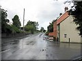
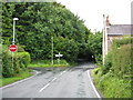
3
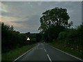
Araf (Slow) sign on the B4314 heading for Narberth
Taken at dusk, the "Araf/Slow" road markings indicate, there is a sharp bend and the road narrows on both sides ahead, on the B4314 heading north from Princes Gate for Narberth.
Image: © Martyn Harries
Taken: 27 Jul 2013
0.10 miles

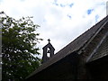
6
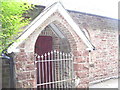
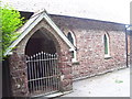
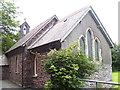
St Catherine's Church, Princes Gate - porch
Image: © welshbabe
Taken: 7 Aug 2015
0.10 miles
7
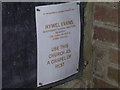
St Catherine's Church, Princes Gate - notice in porch
Image: © welshbabe
Taken: 7 Aug 2015
0.10 miles