IMAGES TAKEN NEAR TO
Templeton, NARBERTH, SA67 8SR
Introduction
This page details the photographs taken nearby to SA67 8SR by members of the Geograph project.
The Geograph project started in 2005 with the aim of publishing, organising and preserving representative images for every square kilometre of Great Britain, Ireland and the Isle of Man.

There are currently over 7.5m images from over14,400 individuals and you can help contribute to the project by visiting https://www.geograph.org.uk
Image Map (Loading...)


Getting Data...Please wait
Leaflet Map data © OpenStreetMap
Images are licensed for reuse under creativecommons.org/licenses/by-sa/2.0
Notes
- Clicking on the map will re-center to the selected point.
- The higher the marker number, the further away the image location is from the centre of the postcode.
Image Listing (19 Images Found)
Images are licensed for reuse under creativecommons.org/licenses/by-sa/2.0
Image
Details
Distance
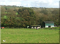
1

On the A478 looking down into Templeton
Image: © Andy Lesnianski
Taken: 23 Oct 2005
0.05 miles
2
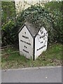
Old Milestone by the A478, south of Templeton, Templeton Parish
Pembroke double plate by the A478, in parish of Templeton (Pembrokeshire District), South of Templeton village, in front of Templeton House.
Inscription reads:-
: 7 / MILES / 970 YARDS / TO / TENBY : : 3 / MILES / TO / NARBERTH :
Grade II listed by Cadw. Reference Number: 18981
https://cadwpublic-api.azurewebsites.net/reports/listedbuilding/FullReport?lang=&id=18981
Surveyed
Milestone Society National ID: PEM_TBNB07
Image: © Milestone Society
Taken: Unknown
0.14 miles
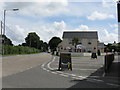
4

Pembrokeshire Pubs: Boars Head, Templeton
Image: © Shaun Butler
Taken: 23 Sep 2008
0.17 miles

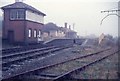
6
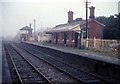
Templeton Railway Station
The station buildings and signal box before being demolished
Image: © Tudor Williams
Taken: Unknown
0.18 miles
7
Templeton Railway Station
The station and signal box before being demolished. H.M. The Queen Mother whilst on board the Royal Train spent the night in the siding. She was en. route to the then named Regent Refinery to officially open the refinery the following day
Image: © Tudor Williams
Taken: Unknown
0.18 miles

9

Old Milestone by the A478, Templeton
Stone disc by the A478, in parish of Templeton (Pembrokeshire District), in village, by junction with Tanner's Lane, East side of road. This is a replacement stone. The stone to the right could be the original but it is missing its metal plate. https://www.facebook.com/groups/MilestoneSociety/permalink/7311814682189419
Inscription reads:-
NARBERTH
2M <
TENBY 8M >
Surveyed
Milestone Society National ID: PEM_TBNB08
Image: © Milestone Society
Taken: 1 Jan 2012
0.20 miles