IMAGES TAKEN NEAR TO
Templeton, NARBERTH, SA67 8SP
Introduction
This page details the photographs taken nearby to SA67 8SP by members of the Geograph project.
The Geograph project started in 2005 with the aim of publishing, organising and preserving representative images for every square kilometre of Great Britain, Ireland and the Isle of Man.

There are currently over 7.5m images from over14,400 individuals and you can help contribute to the project by visiting https://www.geograph.org.uk
Image Map
Images are licensed for reuse under creativecommons.org/licenses/by-sa/2.0
Notes
- Clicking on the map will re-center to the selected point.
- The higher the marker number, the further away the image location is from the centre of the postcode.
Image Listing (5 Images Found)
Images are licensed for reuse under creativecommons.org/licenses/by-sa/2.0
Image
Details
Distance

2
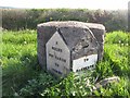
Old Milestone by the A478, Kilgetty parish, Pembrokeshire
Pembroke double plate by the A478, in parish of Kilgetty/Begelly (Pembrokeshire D
Inscription reads:-
: 6 / MILES / 970 YARDS / TO / TENBY : : (4 / MILES) / TO / NARBERTH :
Carved bench mark and rivet on top.
Surveyed
Milestone Society National ID: PEM_TBNB06
Image: © Milestone Society
Taken: Unknown
0.19 miles
3
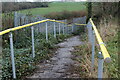
Path from lay-by to railway line
The concrete path leads via a locked gate to what appears to be a small platform next to the line.
Image: © M J Roscoe
Taken: 28 Nov 2021
0.20 miles
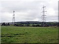
5
Power Lines At Winfield
The A478 is crossed by twin 400Kv lines from Pembroke Power Station.
Image: © Peter Whatley
Taken: 21 Jul 2009
0.24 miles