IMAGES TAKEN NEAR TO
Templeton, NARBERTH, SA67 8SN
Introduction
This page details the photographs taken nearby to SA67 8SN by members of the Geograph project.
The Geograph project started in 2005 with the aim of publishing, organising and preserving representative images for every square kilometre of Great Britain, Ireland and the Isle of Man.

There are currently over 7.5m images from over14,400 individuals and you can help contribute to the project by visiting https://www.geograph.org.uk
Image Map
Images are licensed for reuse under creativecommons.org/licenses/by-sa/2.0
Notes
- Clicking on the map will re-center to the selected point.
- The higher the marker number, the further away the image location is from the centre of the postcode.
Image Listing (16 Images Found)
Images are licensed for reuse under creativecommons.org/licenses/by-sa/2.0
Image
Details
Distance
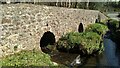
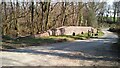
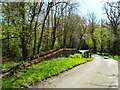
6
Old Footbridge
Old stone bridge over stream - now hardly used as the stream has a proper road - but must have been used a lot at one time to get over the water.
Image: © welshbabe
Taken: 24 Jul 2020
0.22 miles
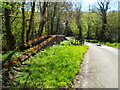
7
Old Footbridge
Old stone bridge over stream - now hardly used as the stream has a proper road - but must have been used a lot at one time to get over the water.
Image: © welshbabe
Taken: 24 Jul 2020
0.22 miles
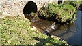
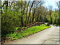
9
Old Footbridge
Old stone bridge over stream - now hardly used as the stream has a proper road - but must have been used a lot at one time to get over the water.
Image: © welshbabe
Taken: 24 Jul 2020
0.23 miles
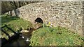
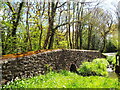
10
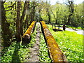
Old Footbridge
View across the narrow stone bridge.
Image: © welshbabe
Taken: 24 Jul 2020
0.23 miles