IMAGES TAKEN NEAR TO
Templeton, NARBERTH, SA67 8SE
Introduction
This page details the photographs taken nearby to SA67 8SE by members of the Geograph project.
The Geograph project started in 2005 with the aim of publishing, organising and preserving representative images for every square kilometre of Great Britain, Ireland and the Isle of Man.

There are currently over 7.5m images from over14,400 individuals and you can help contribute to the project by visiting https://www.geograph.org.uk
Image Map (Loading...)


Getting Data...Please wait
Leaflet Map data © OpenStreetMap
Images are licensed for reuse under creativecommons.org/licenses/by-sa/2.0
Notes
- Clicking on the map will re-center to the selected point.
- The higher the marker number, the further away the image location is from the centre of the postcode.
Image Listing (6 Images Found)
Images are licensed for reuse under creativecommons.org/licenses/by-sa/2.0
Image
Details
Distance
1
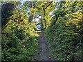
The bridleway approaching the A4115
The house in view has the curious name of Peter's Finger.
Image: © David Medcalf
Taken: 10 Aug 2022
0.01 miles
2
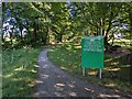
A notice at the entrance to Templeton airfield site
The airfield is disused and the notice lets people know that no training is taking place so they can go anywhere on the site.
Image: © David Medcalf
Taken: 10 Aug 2022
0.07 miles
3
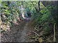
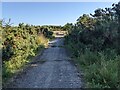
Looking south along the bridleway
The deep trough of the path probably indicates that it has been in use for a long time.
Image: © David Medcalf
Taken: 10 Aug 2022
0.08 miles
4
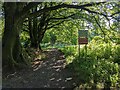
Notices at the entrance to Templeton airfield
The disused airfield has been used for army training. The notices stress the "duty of care" that is required from all taking part. In essence.."Remember that you didn't join the army to kill people by accident".
Image: © David Medcalf
Taken: 10 Aug 2022
0.08 miles
5
A concrete lane at Templeton disused airfield
Image: © David Medcalf
Taken: 10 Aug 2022
0.13 miles
6

Looking north along the bridleway
The deep trough of the path probably indicates that it has been in use for a long time.
Image: © David Medcalf
Taken: 10 Aug 2022
0.16 miles