IMAGES TAKEN NEAR TO
Templeton, NARBERTH, SA67 8RU
Introduction
This page details the photographs taken nearby to SA67 8RU by members of the Geograph project.
The Geograph project started in 2005 with the aim of publishing, organising and preserving representative images for every square kilometre of Great Britain, Ireland and the Isle of Man.

There are currently over 7.5m images from over14,400 individuals and you can help contribute to the project by visiting https://www.geograph.org.uk
Image Map
Images are licensed for reuse under creativecommons.org/licenses/by-sa/2.0
Notes
- Clicking on the map will re-center to the selected point.
- The higher the marker number, the further away the image location is from the centre of the postcode.
Image Listing (18 Images Found)
Images are licensed for reuse under creativecommons.org/licenses/by-sa/2.0
Image
Details
Distance
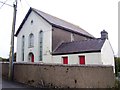
1
Chapel, Chapel Street, Templeton - new graveyard
Image: © welshbabe
Taken: 10 Oct 2015
0.05 miles
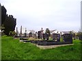
2
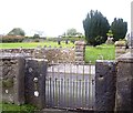
Templeton - Chapel Street entrance to new graveyard
Image: © welshbabe
Taken: 10 Oct 2015
0.06 miles
3
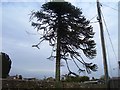
Chapel Street, Templeton - tree by new graveyard
Image: © welshbabe
Taken: 10 Oct 2015
0.06 miles
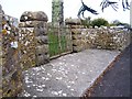
4
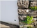
Ordnance Survey Cut Mark
This OS cut mark can be found on the wall east side of Temple View. It marks a point 137.750m above mean sea level.
Image: © Adrian Dust
Taken: 22 Mar 2022
0.06 miles
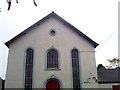
6
Chapel, Chapel Street, Templeton - looking towards new graveyard
Image: © welshbabe
Taken: 10 Oct 2015
0.07 miles
7
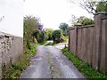
Lane by side of Chapel, Chapel Lane, Templeton
Image: © welshbabe
Taken: 10 Oct 2015
0.08 miles