IMAGES TAKEN NEAR TO
Stepaside, NARBERTH, SA67 8PN
Introduction
This page details the photographs taken nearby to SA67 8PN by members of the Geograph project.
The Geograph project started in 2005 with the aim of publishing, organising and preserving representative images for every square kilometre of Great Britain, Ireland and the Isle of Man.

There are currently over 7.5m images from over14,400 individuals and you can help contribute to the project by visiting https://www.geograph.org.uk
Image Map (12 Images)


Getting Data...Please wait
Leaflet Map data © OpenStreetMap
Images are licensed for reuse under creativecommons.org/licenses/by-sa/2.0
Notes
- Clicking on the map will re-center to the selected point.
- The higher the marker number, the further away the image location is from the centre of the postcode.
Image Listing (12 Images Found)
Images are licensed for reuse under creativecommons.org/licenses/by-sa/2.0
Image
Details
Distance
1
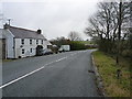
The Coach House, near Summerhill
Older maps, including the 1953 1:10560 scale, mark this as The Commercial Inn, but it is now a private house.
Image: © Richard Law
Taken: 26 Dec 2019
0.01 miles
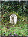
2
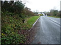
The Summerhill milestone in its setting
Located beside the road running north past The Coach House, a former public house.
Image: © Richard Law
Taken: 26 Dec 2019
0.02 miles
3
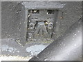
Ordnance Survey Flush Bracket S7947
This partly buried bracket can be found on the wall of the former Commercial Inn.
For more detail see : http://www.bench-marks.org.uk/log?bm_key=21129
Image: © Peter Wood
Taken: 24 May 2013
0.02 miles

5

Milestone near Kilanow Crossroads, Summerhill
20 miles to Carmarthen, 13 miles to Hobbs Point.
Image: © welshbabe
Taken: 16 Apr 2009
0.06 miles
6
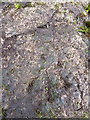
OS rivet - Summerhill, milestone
An OS rivet in the stone milemarker beside the road near Colby. Originally levelled in 1954 at 92.866m above Ordnance Datum Newlyn.
Image: © Richard Law
Taken: 26 Dec 2019
0.06 miles
7
Summerhill milestone
Looking a little the worse for wear since Image was taken about 8 years ago, this milestone lies beside the turnpike road from Stepaside.
Image: © Richard Law
Taken: 26 Dec 2019
0.06 miles
8
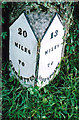
Old Milestone north of Summerhill, Amroth parish
Pembroke double plate by the UC, in parish of Amroth (Pembrokeshire District), North of Summerhill, South of Kilanow.
Inscription reads:-
: 20 / MILES / TO / CARMARTHEN : : 13 / MILES / TO / HOBBSPOINT :
Surveyed
Milestone Society National ID: PEM_CMHP20
Image: © Milestone Society
Taken: Unknown
0.06 miles
9
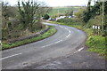
Minor road near Killanow
Bend in road, former A477, just before crossroads.
Image: © M J Roscoe
Taken: 27 Nov 2021
0.18 miles
10
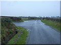
Minor lane near Merrixton House Farm
The lane runs from Summerhill towards Stepaside.
Image: © Richard Law
Taken: 26 Dec 2019
0.20 miles