IMAGES TAKEN NEAR TO
Amroth, NARBERTH, SA67 8NW
Introduction
This page details the photographs taken nearby to SA67 8NW by members of the Geograph project.
The Geograph project started in 2005 with the aim of publishing, organising and preserving representative images for every square kilometre of Great Britain, Ireland and the Isle of Man.

There are currently over 7.5m images from over14,400 individuals and you can help contribute to the project by visiting https://www.geograph.org.uk
Image Map (Loading...)


Getting Data...Please wait
Leaflet Map data © OpenStreetMap
Images are licensed for reuse under creativecommons.org/licenses/by-sa/2.0
Notes
- Clicking on the map will re-center to the selected point.
- The higher the marker number, the further away the image location is from the centre of the postcode.
Image Listing (90 Images Found)
Images are licensed for reuse under creativecommons.org/licenses/by-sa/2.0
Image
Details
Distance

3
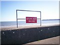
Sign - Amroth seafront
Very useful for holiday makers!
Image: © welshbabe
Taken: 12 Apr 2009
0.03 miles
4
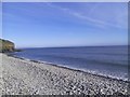
Amroth Seafront
Looking west from New Inn Bridge with Amroth Castle in the distance on the right (grey building).
Image: © welshbabe
Taken: 9 Jan 2009
0.03 miles
5
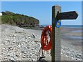
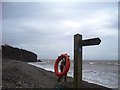
One end of the Pembrokeshire Coast Path National Trail, Amroth
The sign gives the distance of 186 miles to the other end at St Dogmaels (Welsh: Llandudoch).
The Pembrokeshire Coast Path is way marked by an acorn.
The blue and yellow way markers indicate that it is also part of the Wales Coast Path.
Image: © Robin Drayton
Taken: 17 May 2014
0.03 miles
6
Amroth - one end of the Pembrokeshire Coast Path
Image: © welshbabe
Taken: 5 Feb 2016
0.03 miles
7
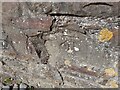
Ordnance Survey Cut Mark
This OS cut mark can be found on the north parapet of the New Inn Bridge. It marks a point 7.489m above mean sea level.
Image: © Adrian Dust
Taken: 7 Apr 2022
0.03 miles
9
OS benchmark - Amroth, The New Inn bridge
Located on the northern parapet of the bridge, and levelled in 1954 at 7.489m above Ordnance Datum Newlyn.
Image: © Richard Law
Taken: 22 Dec 2019
0.04 miles
10
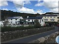
New Inn, Amroth
New Inn and bridge, Amroth.
Image: © Alan Hughes
Taken: 1 Sep 2017
0.04 miles