IMAGES TAKEN NEAR TO
Pleasant Valley, Stepaside, NARBERTH, SA67 8NT
Introduction
This page details the photographs taken nearby to SA67 8NT by members of the Geograph project.
The Geograph project started in 2005 with the aim of publishing, organising and preserving representative images for every square kilometre of Great Britain, Ireland and the Isle of Man.

There are currently over 7.5m images from over14,400 individuals and you can help contribute to the project by visiting https://www.geograph.org.uk
Image Map (Loading...)


Getting Data...Please wait
Leaflet Map data © OpenStreetMap
Images are licensed for reuse under creativecommons.org/licenses/by-sa/2.0
Notes
- Clicking on the map will re-center to the selected point.
- The higher the marker number, the further away the image location is from the centre of the postcode.
Image Listing (22 Images Found)
Images are licensed for reuse under creativecommons.org/licenses/by-sa/2.0
Image
Details
Distance
1
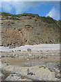
Carmarthen Bay
Carmarthen Bay glimpsed through woodland.
Image: © Alan Hughes
Taken: 12 Jan 2022
0.08 miles
3
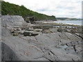
Pembrokeshire Coast Path
Pembrokeshire Coast Path from Wiseman's Bridge heading to Amroth
Image: © Shaun Ferguson
Taken: 8 Apr 2018
0.13 miles
5
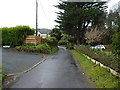
Cliff Road joins the lane down into Wiseman's Bridge
Image: © Richard Law
Taken: 21 Dec 2019
0.15 miles
7
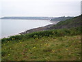
View from Tinker Hill
Looking south west towards Wiseman's Bridge.
Image: © Kevin Trahar
Taken: 26 Jul 2004
0.19 miles
9
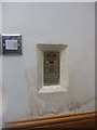
OS Flush Bracket G5120 - Sea View House, Pleasant Valley
This OS flush bracket is now inside the house, as the front appears to have been extended; the owner and builder very considerately left it as a feature in the wall. Originally levelled in 1962 at 25.05m above Ordnance Datum Newlyn as part of the 3rd geodetic levelling of England and Wales, on the Haverfordwest to Carmarthen survey line.
Image: © Richard Law
Taken: 26 Dec 2019
0.20 miles
10
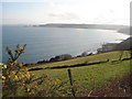
Tinkershill fields
From the coast path there is a good view across Saundersfoot Bay to Monkstone Point and Caldey Island.
Image: © Trevor Rickard
Taken: 14 Mar 2007
0.20 miles