IMAGES TAKEN NEAR TO
Amroth, NARBERTH, SA67 8NB
Introduction
This page details the photographs taken nearby to SA67 8NB by members of the Geograph project.
The Geograph project started in 2005 with the aim of publishing, organising and preserving representative images for every square kilometre of Great Britain, Ireland and the Isle of Man.

There are currently over 7.5m images from over14,400 individuals and you can help contribute to the project by visiting https://www.geograph.org.uk
Image Map (Loading...)


Getting Data...Please wait
Leaflet Map data © OpenStreetMap
Images are licensed for reuse under creativecommons.org/licenses/by-sa/2.0
Notes
- Clicking on the map will re-center to the selected point.
- The higher the marker number, the further away the image location is from the centre of the postcode.
Image Listing (131 Images Found)
Images are licensed for reuse under creativecommons.org/licenses/by-sa/2.0
Image
Details
Distance
1
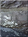
OS benchmark - Amroth, wall outside no 2 Sea View
Built into the boundary wall of the last house on the seafront (heading west); the mark was levelled in 1954 at 11.631m above Ordnance Datum Newlyn.
Image: © Richard Law
Taken: 22 Dec 2019
0.00 miles
2
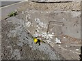
Ordnance Survey Cut Mark
This OS cut mark can be found on the wall of No2 Sea View. It marks a point 11.631m above mean sea level.
Image: © Adrian Dust
Taken: 7 Apr 2022
0.00 miles
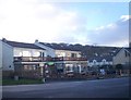
3

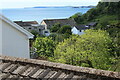
View over Amroth
View from the woodland Coast Path; the near house is Sea View Cottage. The orange building is the rear of a seafront public house, The Smugglers.
Image: © M J Roscoe
Taken: 22 Aug 2023
0.00 miles
4
View over Amroth to sea
View to houses overlooking the beach from Knights' Way at Upper Mead. Monkstone can be seen across the bay top right.
Image: © M J Roscoe
Taken: 31 May 2022
0.01 miles
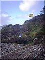
5

Footpath down towards public conveniences
The woodland Coast Path drops down to the end of the seafront. The tree trunk conceals a flight of steps.
Image: © M J Roscoe
Taken: 22 Aug 2023
0.01 miles
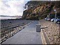
6
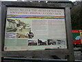
Industrial Amroth
A notice board at the western end of the promenade describing what life would have been like here 200 years ago
Image: © Eirian Evans
Taken: 25 Sep 2022
0.01 miles
10
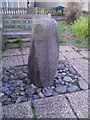
Amroth - large stone in community garden
Image: © welshbabe
Taken: 12 Apr 2017
0.02 miles