IMAGES TAKEN NEAR TO
Amroth, NARBERTH, SA67 8NA
Introduction
This page details the photographs taken nearby to SA67 8NA by members of the Geograph project.
The Geograph project started in 2005 with the aim of publishing, organising and preserving representative images for every square kilometre of Great Britain, Ireland and the Isle of Man.

There are currently over 7.5m images from over14,400 individuals and you can help contribute to the project by visiting https://www.geograph.org.uk
Image Map (Loading...)


Getting Data...Please wait
Leaflet Map data © OpenStreetMap
Images are licensed for reuse under creativecommons.org/licenses/by-sa/2.0
Notes
- Clicking on the map will re-center to the selected point.
- The higher the marker number, the further away the image location is from the centre of the postcode.
Image Listing (120 Images Found)
Images are licensed for reuse under creativecommons.org/licenses/by-sa/2.0
Image
Details
Distance
1
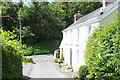
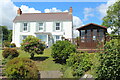
Groveside, Amroth
White house at junction of highway and private road.
Image: © M J Roscoe
Taken: 31 May 2022
0.07 miles
2
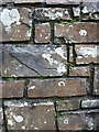
OS benchmark - Amroth, wall by The Avenue
A repositioned benchmark on the retaining wall outside a row of cottages; originally levelled in 1954 at 46.903m above Ordnance Datum Newlyn, but clearly no longer reliable as a mark as the wall has been rebuilt.
Image: © Richard Law
Taken: 23 Dec 2019
0.07 miles
3
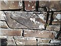
Ordnance Survey Cut Mark
This inverted OS cut mark can be found on the wall of The Avenue. It marked a point 46.903m above mean sea level.
Image: © Adrian Dust
Taken: 7 Apr 2022
0.07 miles
5

Rear garden of house on Cliff Road
Terraced garden of Sound of the Sea at the end of Cliff Road.
Image: © M J Roscoe
Taken: 22 Aug 2023
0.09 miles
6
Beulah, Amroth
House overlooking Amroth.
Image: © M J Roscoe
Taken: 31 May 2022
0.09 miles
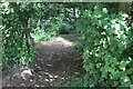
8

Pedestrian gate at top of woodland path
The Coast Path leaves the wooded hillside and moves to open country behind camera. The white oval on the gate post gives the location and grid reference.
Image: © M J Roscoe
Taken: 22 Aug 2023
0.10 miles
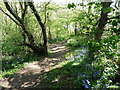
9
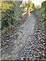
Woodland footpath below pedestrian gate
End of steep climb on Coast Path up steps through pine trees from Amroth seafront.
Image: © M J Roscoe
Taken: 22 Aug 2023
0.10 miles
10
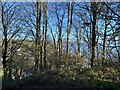
A glimpse of Amroth
Amroth and Amroth beach glimpsed through woodland on the cliff path from Wiseman’s Bridge.
Image: © Alan Hughes
Taken: 12 Jan 2022
0.12 miles