IMAGES TAKEN NEAR TO
Church View, Summerhill, NARBERTH, SA67 8LZ
Introduction
This page details the photographs taken nearby to Church View, Summerhill, SA67 8LZ by members of the Geograph project.
The Geograph project started in 2005 with the aim of publishing, organising and preserving representative images for every square kilometre of Great Britain, Ireland and the Isle of Man.

There are currently over 7.5m images from over14,400 individuals and you can help contribute to the project by visiting https://www.geograph.org.uk
Image Map (Loading...)


Getting Data...Please wait
Leaflet Map data © OpenStreetMap
Images are licensed for reuse under creativecommons.org/licenses/by-sa/2.0
Notes
- Clicking on the map will re-center to the selected point.
- The higher the marker number, the further away the image location is from the centre of the postcode.
Image Listing (7 Images Found)
Images are licensed for reuse under creativecommons.org/licenses/by-sa/2.0
Image
Details
Distance
2
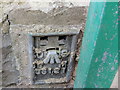
Ordnance Survey Flush Bracket G5121
This can be found on the wall of the former Summerhill Methodist Church - now a private dwelling.
For more detail see : http://www.bench-marks.org.uk/log?bm_key=13232
Image: © Peter Wood
Taken: 24 May 2013
0.10 miles
3
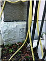
OS flush bracket - Summerhill, former Methodist Chapel
Flush Bracket G5121 which is affixed low on the side wall of Image It was levelled in 1969 at 87.735m above Ordnance Datum Newlyn as part of the 3rd Geodetic levelling of England and Wales.
Image: © Richard Law
Taken: 23 Dec 2019
0.10 miles
4
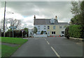
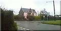
Crossroads in the centre of Summerhill
The main building visible here is the converted/former Methodist Chapel, which is now a private house. Summerhill is otherwise pretty much devoid of facilities, no shop, no pub etc.
Image: © Richard Law
Taken: 23 Dec 2019
0.10 miles
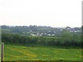
7
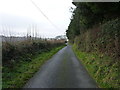
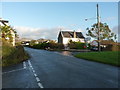
Lane to the west of Summerhill
Thisw un-named lane leads to Stepaside village.
Image: © Richard Law
Taken: 25 Dec 2019
0.23 miles