IMAGES TAKEN NEAR TO
Rosemary Lane, NARBERTH, SA67 8JY
Introduction
This page details the photographs taken nearby to Rosemary Lane, SA67 8JY by members of the Geograph project.
The Geograph project started in 2005 with the aim of publishing, organising and preserving representative images for every square kilometre of Great Britain, Ireland and the Isle of Man.

There are currently over 7.5m images from over14,400 individuals and you can help contribute to the project by visiting https://www.geograph.org.uk
Image Map (Loading...)


Getting Data...Please wait
Leaflet Map data © OpenStreetMap
Images are licensed for reuse under creativecommons.org/licenses/by-sa/2.0
Notes
- Clicking on the map will re-center to the selected point.
- The higher the marker number, the further away the image location is from the centre of the postcode.
Image Listing (3 Images Found)
Images are licensed for reuse under creativecommons.org/licenses/by-sa/2.0
Image
Details
Distance
2
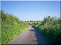
Rosemary Lane, Ludchurch
Part of lane down towards the A477 trunk road.
Image: © welshbabe
Taken: 2 Jun 2009
0.19 miles
3
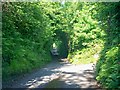
Rosemary Lane, Ludchurch
Lovely avenue of trees in this secluded lane - but not as nice as it once was - trees used to be much thicker.
Image: © welshbabe
Taken: 2 Jun 2009
0.19 miles