IMAGES TAKEN NEAR TO
Stepaside, NARBERTH, SA67 8JX
Introduction
This page details the photographs taken nearby to SA67 8JX by members of the Geograph project.
The Geograph project started in 2005 with the aim of publishing, organising and preserving representative images for every square kilometre of Great Britain, Ireland and the Isle of Man.

There are currently over 7.5m images from over14,400 individuals and you can help contribute to the project by visiting https://www.geograph.org.uk
Image Map (Loading...)


Getting Data...Please wait
Leaflet Map data © OpenStreetMap
Images are licensed for reuse under creativecommons.org/licenses/by-sa/2.0
Notes
- Clicking on the map will re-center to the selected point.
- The higher the marker number, the further away the image location is from the centre of the postcode.
Image Listing (39 Images Found)
Images are licensed for reuse under creativecommons.org/licenses/by-sa/2.0
Image
Details
Distance
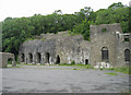
1
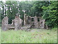
Grove Colliery, Stepaside
Winding engine houses for Grove colliery. The original winder was on the left. It was replaced by a vertical winding engine located in a new house built to the right of the original building. This was probably installed when the shaft was deepened in 1873. Winding of coal ceased around 1884.
Image: © Stephen Dewhirst
Taken: 6 Jul 2008
0.13 miles
2
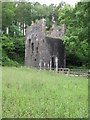
Grove Colliery, Stepaside
Engine house for Cornish Beam engine which pumped water from the mine. This was a 274 horse power engine with an 80" diameter cylinder. The shaft was in front of the building and was 298 metres deep.
Image: © Stephen Dewhirst
Taken: 6 Jul 2008
0.15 miles
3
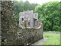
Grove Colliery, Stepaside
Linked to the nearby Kilgetty ironworks, Grove Colliery was sunk between 1853 and 1858 closing around 1903.
Image: © Stephen Dewhirst
Taken: 6 Jul 2008
0.16 miles
4
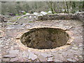
Shaft at the top of a kiln, Kilgetty Iron Works
This is where material was shovelled into the kiln.
Image: © Humphrey Bolton
Taken: 22 Mar 2005
0.18 miles
5
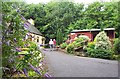
Stepaside Craft Village
A collection of chalets on the wooded hillside where local craftsmen exhibit their skills and display their wares for sale.
Image: © Garth Newton
Taken: 10 Jul 2001
0.19 miles
6

Bluebell time in the woods above Grove Colliery
Image: © Pauline Evans
Taken: 4 May 2007
0.19 miles
7
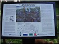
Sign board at Grove Colliery ruins between Sardis and Stepaside.
That's not a fox at the bottom right-hand corner of the picture, it's one of my Dogs :)
Image: © Pauline Evans
Taken: 4 May 2007
0.19 miles
8
Kilgetty Iron Works
The remains of the furnace walls at Kilgetty Iron Works
Image: © Peter Wasp
Taken: 25 Jun 2006
0.19 miles
9
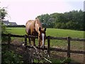
Tom in his field in Sardis.
Woodside Farmhouse in the background.
Image: © Pauline Evans
Taken: 4 May 2007
0.19 miles
10
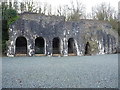
The Furnace Bank Revetment Wall
Self-evidently part of the extensive former Kilgetty Ironworks buildings; this wall with its 4 vaulted openings stood behind the original furnaces which no longer exist. It dates from the mid 19th century, and attracted a Grade II listing https://britishlistedbuildings.co.uk/300018278-furnace-bank-revetment-wall-kilgettybegelly#.XmiS6Kj7RPY & http://cadwpublic-api.azurewebsites.net/reports/listedbuilding/FullReport?lang=en&id=18278 in 1997.
Image: © Richard Law
Taken: 25 Dec 2019
0.23 miles