IMAGES TAKEN NEAR TO
Stepaside, NARBERTH, SA67 8JT
Introduction
This page details the photographs taken nearby to SA67 8JT by members of the Geograph project.
The Geograph project started in 2005 with the aim of publishing, organising and preserving representative images for every square kilometre of Great Britain, Ireland and the Isle of Man.

There are currently over 7.5m images from over14,400 individuals and you can help contribute to the project by visiting https://www.geograph.org.uk
Image Map (Loading...)


Getting Data...Please wait
Leaflet Map data © OpenStreetMap
Images are licensed for reuse under creativecommons.org/licenses/by-sa/2.0
Notes
- Clicking on the map will re-center to the selected point.
- The higher the marker number, the further away the image location is from the centre of the postcode.
Image Listing (20 Images Found)
Images are licensed for reuse under creativecommons.org/licenses/by-sa/2.0
Image
Details
Distance
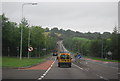
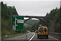
3
Descent from Kilgetty towards the A477
Beyond the eastern boundary of Kilgetty, Carmarthen Road descends towards the A477.
Image: © Jaggery
Taken: 6 Jan 2018
0.12 miles
6
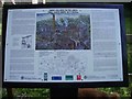
Sign board at Grove Colliery ruins between Sardis and Stepaside.
That's not a fox at the bottom right-hand corner of the picture, it's one of my Dogs :)
Image: © Pauline Evans
Taken: 4 May 2007
0.15 miles
7
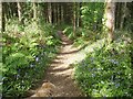
Bluebell time in the woods above Grove Colliery
Image: © Pauline Evans
Taken: 4 May 2007
0.17 miles
8
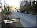
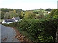
Stepaside
Cerddwyr yn cyrraedd pentre Stepaside.
Walkers arriving at Stepaside Village.
Image: © Alan Richards
Taken: 27 Feb 2005
0.18 miles
10
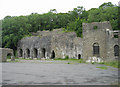
Kilgetty Iron Works
The remains of the furnace walls at Kilgetty Iron Works
Image: © Peter Wasp
Taken: 25 Jun 2006
0.21 miles