IMAGES TAKEN NEAR TO
Egypt Meadow, NARBERTH, SA67 8HY
Introduction
This page details the photographs taken nearby to Egypt Meadow, SA67 8HY by members of the Geograph project.
The Geograph project started in 2005 with the aim of publishing, organising and preserving representative images for every square kilometre of Great Britain, Ireland and the Isle of Man.

There are currently over 7.5m images from over14,400 individuals and you can help contribute to the project by visiting https://www.geograph.org.uk
Image Map (Loading...)


Getting Data...Please wait
Leaflet Map data © OpenStreetMap
Images are licensed for reuse under creativecommons.org/licenses/by-sa/2.0
Notes
- Clicking on the map will re-center to the selected point.
- The higher the marker number, the further away the image location is from the centre of the postcode.
Image Listing (2 Images Found)
Images are licensed for reuse under creativecommons.org/licenses/by-sa/2.0
Image
Details
Distance
1
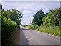
Road from Longstone Chapel towards Ludchurch.
Image: © welshbabe
Taken: 25 Jun 2009
0.21 miles
2
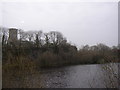
Ludchurch Lake and Church
St Elidyr's Church is almost surrounded by a disused limestone quarry, now wooded and with ponds of water, the largest of which is in this photo and is next to the road.
Image: © Humphrey Bolton
Taken: 21 Mar 2005
0.24 miles