IMAGES TAKEN NEAR TO
Bethesda, NARBERTH, SA67 8HG
Introduction
This page details the photographs taken nearby to SA67 8HG by members of the Geograph project.
The Geograph project started in 2005 with the aim of publishing, organising and preserving representative images for every square kilometre of Great Britain, Ireland and the Isle of Man.

There are currently over 7.5m images from over14,400 individuals and you can help contribute to the project by visiting https://www.geograph.org.uk
Image Map (Loading...)


Getting Data...Please wait
Leaflet Map data © OpenStreetMap
Images are licensed for reuse under creativecommons.org/licenses/by-sa/2.0
Notes
- Clicking on the map will re-center to the selected point.
- The higher the marker number, the further away the image location is from the centre of the postcode.
Image Listing (3 Images Found)
Images are licensed for reuse under creativecommons.org/licenses/by-sa/2.0
Image
Details
Distance
1
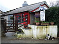
Bethesda farm shop
A friendly dog beside the old churn-stand awaits customers at the self-service sale point for the farm's fresh and delicious dairy produce.
Image: © Natasha Ceridwen de Chroustchoff
Taken: 18 Aug 2007
0.11 miles
2

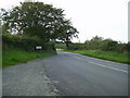
Llaeth Bethesda
On a country road northeast of the tiny hamlet of Bethesda a sign outside Sarn-gwm advertises milk from the farm's own herd.
Image: © Natasha Ceridwen de Chroustchoff
Taken: 18 Aug 2007
0.12 miles
3
Bethesda Village Sign
The village sign positioned close to the hedge by the B4313 from Maenclochog.
Image: © Martyn Harries
Taken: 8 Oct 2010
0.19 miles