IMAGES TAKEN NEAR TO
Llawhaden, NARBERTH, SA67 8DP
Introduction
This page details the photographs taken nearby to SA67 8DP by members of the Geograph project.
The Geograph project started in 2005 with the aim of publishing, organising and preserving representative images for every square kilometre of Great Britain, Ireland and the Isle of Man.

There are currently over 7.5m images from over14,400 individuals and you can help contribute to the project by visiting https://www.geograph.org.uk
Image Map (Loading...)


Getting Data...Please wait
Leaflet Map data © OpenStreetMap
Images are licensed for reuse under creativecommons.org/licenses/by-sa/2.0
Notes
- Clicking on the map will re-center to the selected point.
- The higher the marker number, the further away the image location is from the centre of the postcode.
Image Listing (3 Images Found)
Images are licensed for reuse under creativecommons.org/licenses/by-sa/2.0
Image
Details
Distance
1
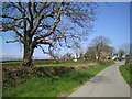
Lane by Potterslade
On the lane to Broadway. Just visible on the skyline is Foel Cwm Cerwym, at 536m the highest point in the Pembrokeshire Coast National Park, about 8 miles to the north.
Image: © John Winterbottom
Taken: 28 Apr 2006
0.18 miles
2
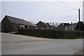
Farm buildings at Broadway
Farm buildings at Broadway near Gelli.
Image: © Philip Halling
Taken: 7 Apr 2013
0.21 miles
3
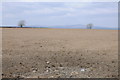
Arable field, Broadway near Gelli
View across an arable field opposite Broadway near Gelli. The Preseli Hills or Mountains/Mynydd Y Preseli can be seen on the horizon.
Image: © Philip Halling
Taken: 7 Apr 2013
0.23 miles