IMAGES TAKEN NEAR TO
Llawhaden, NARBERTH, SA67 8DN
Introduction
This page details the photographs taken nearby to SA67 8DN by members of the Geograph project.
The Geograph project started in 2005 with the aim of publishing, organising and preserving representative images for every square kilometre of Great Britain, Ireland and the Isle of Man.

There are currently over 7.5m images from over14,400 individuals and you can help contribute to the project by visiting https://www.geograph.org.uk
Image Map (Loading...)


Getting Data...Please wait
Leaflet Map data © OpenStreetMap
Images are licensed for reuse under creativecommons.org/licenses/by-sa/2.0
Notes
- Clicking on the map will re-center to the selected point.
- The higher the marker number, the further away the image location is from the centre of the postcode.
Image Listing (3 Images Found)
Images are licensed for reuse under creativecommons.org/licenses/by-sa/2.0
Image
Details
Distance
1
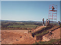
Archaeology in progress (1)
Excavation of an iron age site at Drim by students from Oxford, in the summer of 1981.
Image: © Stephen Craven
Taken: Unknown
0.13 miles
2
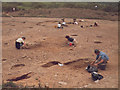
Archaeology in progress (2)
Excavation of an iron age site at Drim as in Image
Image: © Stephen Craven
Taken: Unknown
0.15 miles
3
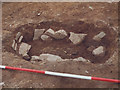
Iron age woman
The only human remains found during the excavation shown in Image Nicknamed "Fred" when first found but believed to be female on closer analysis.
Image: © Stephen Craven
Taken: Unknown
0.16 miles