IMAGES TAKEN NEAR TO
Molleston, NARBERTH, SA67 8BX
Introduction
This page details the photographs taken nearby to SA67 8BX by members of the Geograph project.
The Geograph project started in 2005 with the aim of publishing, organising and preserving representative images for every square kilometre of Great Britain, Ireland and the Isle of Man.

There are currently over 7.5m images from over14,400 individuals and you can help contribute to the project by visiting https://www.geograph.org.uk
Image Map
Images are licensed for reuse under creativecommons.org/licenses/by-sa/2.0
Notes
- Clicking on the map will re-center to the selected point.
- The higher the marker number, the further away the image location is from the centre of the postcode.
Image Listing (5 Images Found)
Images are licensed for reuse under creativecommons.org/licenses/by-sa/2.0
Image
Details
Distance
1
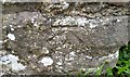
Ordnance Survey Cut Mark
This OS cut mark can be found on the wall at the entrance to The Grove. It marks a point 104.785m above mean sea level.
Image: © Adrian Dust
Taken: 31 Mar 2017
0.05 miles
2
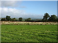
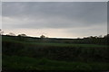
Fields south-west of Narberth
The nearer field is in the grounds of The Grove (hotel). The Preseli Hills can be seen in the distance.
Image: © David Purchase
Taken: 26 Sep 2019
0.15 miles
3
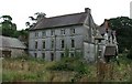
The Grove
Grade II listed building (private house)
It was assessed as having 4 hearths in 1680. The Grove was lived in by the prominent Poyer family.
Image: © Pemb5 Girl
Taken: 29 Jul 2005
0.17 miles
4
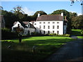
The Grove
About 2 kilometres south-west of Narberth, The Grove is now a luxury hotel.
Image: © David Purchase
Taken: 26 Sep 2019
0.19 miles
5
View from the road from Narberth to Molleston Cross
Image: © Jo and Steve Turner
Taken: 5 May 2008
0.23 miles