IMAGES TAKEN NEAR TO
NARBERTH, SA67 8BS
Introduction
This page details the photographs taken nearby to SA67 8BS by members of the Geograph project.
The Geograph project started in 2005 with the aim of publishing, organising and preserving representative images for every square kilometre of Great Britain, Ireland and the Isle of Man.

There are currently over 7.5m images from over14,400 individuals and you can help contribute to the project by visiting https://www.geograph.org.uk
Image Map (Loading...)


Getting Data...Please wait
Leaflet Map data © OpenStreetMap
Images are licensed for reuse under creativecommons.org/licenses/by-sa/2.0
Notes
- Clicking on the map will re-center to the selected point.
- The higher the marker number, the further away the image location is from the centre of the postcode.
Image Listing (3 Images Found)
Images are licensed for reuse under creativecommons.org/licenses/by-sa/2.0
Image
Details
Distance
1

Entrance gate posts at The Valley near Narberth
Nice classy old entrance way and gateposts. The property is not visible from the road.
Image: © Jeremy Bolwell
Taken: 11 Jul 2011
0.04 miles
3
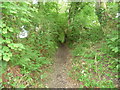
Green lane bridleway near Narberth Bridge
This little field access track or green lane becomes a sunken path at the top of the slope. Presumably used for centuries.
Image: © Jeremy Bolwell
Taken: 11 Jul 2011
0.25 miles