IMAGES TAKEN NEAR TO
Llanddewi Velfrey, NARBERTH, SA67 7PH
Introduction
This page details the photographs taken nearby to SA67 7PH by members of the Geograph project.
The Geograph project started in 2005 with the aim of publishing, organising and preserving representative images for every square kilometre of Great Britain, Ireland and the Isle of Man.

There are currently over 7.5m images from over14,400 individuals and you can help contribute to the project by visiting https://www.geograph.org.uk
Image Map (Loading...)


Getting Data...Please wait
Leaflet Map data © OpenStreetMap
Images are licensed for reuse under creativecommons.org/licenses/by-sa/2.0
Notes
- Clicking on the map will re-center to the selected point.
- The higher the marker number, the further away the image location is from the centre of the postcode.
Image Listing (6 Images Found)
Images are licensed for reuse under creativecommons.org/licenses/by-sa/2.0
Image
Details
Distance
4
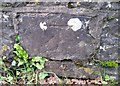
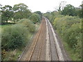
Ordnance Survey Cut Mark
This OS cut mark can be found on the east parapet of the railway bridge. It marks a point 43.474m above mean sea level.
Image: © Adrian Dust
Taken: 15 Jan 2017
0.15 miles
5
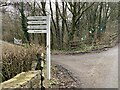
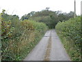
Turning towards Pen Deri
Bed and breakfast near Llanfallteg.
Image: © Alan Hughes
Taken: 7 Feb 2023
0.19 miles