IMAGES TAKEN NEAR TO
Llanddewi Velfrey, NARBERTH, SA67 7PB
Introduction
This page details the photographs taken nearby to SA67 7PB by members of the Geograph project.
The Geograph project started in 2005 with the aim of publishing, organising and preserving representative images for every square kilometre of Great Britain, Ireland and the Isle of Man.

There are currently over 7.5m images from over14,400 individuals and you can help contribute to the project by visiting https://www.geograph.org.uk
Image Map (Loading...)


Getting Data...Please wait
Leaflet Map data © OpenStreetMap
Images are licensed for reuse under creativecommons.org/licenses/by-sa/2.0
Notes
- Clicking on the map will re-center to the selected point.
- The higher the marker number, the further away the image location is from the centre of the postcode.
Image Listing (19 Images Found)
Images are licensed for reuse under creativecommons.org/licenses/by-sa/2.0
Image
Details
Distance
1

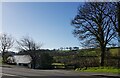
Maes y Dderwen
Housing in Maes y Dderwen, Llanddewi Felfre.
Image: © Alan Hughes
Taken: 15 Apr 2019
0.03 miles
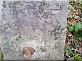
2
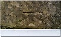
Ordnance Survey Cut Mark
This OS cut mark can be found on the front of the school building. It marks a point 126.166m above mean sea level.
Image: © Adrian Dust
Taken: 15 Jan 2017
0.04 miles
3
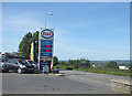
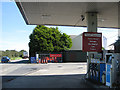
Preseli Services
Fuel, shop and post office by the A40.
Image: © Pauline E
Taken: 12 Sep 2009
0.07 miles
4
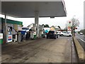
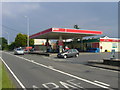
Petrol station
Petrol filling station at Llanddewi Felffre on the A40.
Image: © Alan Hughes
Taken: 5 Oct 2018
0.07 miles
6
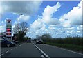
House in a dip, Llanddewi Felffre, Pembrokeshire
Image: © Jeff Gogarty
Taken: 9 Apr 2022
0.08 miles
9
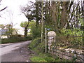
Cilffordd Byway
A few yards to the left of the entrance track to St. David's Church, is this sign, but where the byway is, is not clear even on the map.
Image: © chris whitehouse
Taken: 24 Apr 2012
0.12 miles
10
Ordnance Survey Cut Mark
This OS cut mark can be found on the gatepost east side of the entrance. It marks a point 119.975m above mean sea level.
Image: © Adrian Dust
Taken: 15 Jan 2017
0.12 miles