IMAGES TAKEN NEAR TO
Llanddewi Velfrey, NARBERTH, SA67 7PA
Introduction
This page details the photographs taken nearby to SA67 7PA by members of the Geograph project.
The Geograph project started in 2005 with the aim of publishing, organising and preserving representative images for every square kilometre of Great Britain, Ireland and the Isle of Man.

There are currently over 7.5m images from over14,400 individuals and you can help contribute to the project by visiting https://www.geograph.org.uk
Image Map
Images are licensed for reuse under creativecommons.org/licenses/by-sa/2.0
Notes
- Clicking on the map will re-center to the selected point.
- The higher the marker number, the further away the image location is from the centre of the postcode.
Image Listing (5 Images Found)
Images are licensed for reuse under creativecommons.org/licenses/by-sa/2.0
Image
Details
Distance
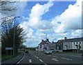
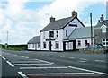
1
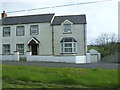
Outskirts of Llanddewi Velfrey
A house on the outskirts of Llanddewi Velfrey.
Image: © Jake Watson
Taken: 26 Apr 2009
0.04 miles
3
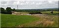
Llanddewi Velfry Bypass Under Construction
The new bypass is being built to the north of the village and will be around two kilometres long.
Image: © Paul Collins
Taken: 6 Jul 2023
0.20 miles