IMAGES TAKEN NEAR TO
Stoneyford, NARBERTH, SA67 7NX
Introduction
This page details the photographs taken nearby to Stoneyford, SA67 7NX by members of the Geograph project.
The Geograph project started in 2005 with the aim of publishing, organising and preserving representative images for every square kilometre of Great Britain, Ireland and the Isle of Man.

There are currently over 7.5m images from over14,400 individuals and you can help contribute to the project by visiting https://www.geograph.org.uk
Image Map (Loading...)


Getting Data...Please wait
Leaflet Map data © OpenStreetMap
Images are licensed for reuse under creativecommons.org/licenses/by-sa/2.0
Notes
- Clicking on the map will re-center to the selected point.
- The higher the marker number, the further away the image location is from the centre of the postcode.
Image Listing (4 Images Found)
Images are licensed for reuse under creativecommons.org/licenses/by-sa/2.0
Image
Details
Distance
1
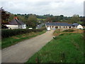
Stonyford
Right at the edge of the grid square, these new barn conversions at Stonyford are named Stoney Barn and Ford Barn; beyond, the road leading towards Narberth dips down to the eponymous ford.
Image: © Natasha Ceridwen de Chroustchoff
Taken: 25 Oct 2007
0.02 miles
2
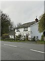
Y Ffermdy - The Farmhouse
On the road to Narberth.
Image: © Alan Hughes
Taken: 14 Nov 2021
0.05 miles
4
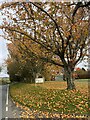
Autumn leaves at the entrance to Beechwood Park
Image: © Alan Hughes
Taken: 14 Nov 2021
0.20 miles