IMAGES TAKEN NEAR TO
NARBERTH, SA67 7EX
Introduction
This page details the photographs taken nearby to SA67 7EX by members of the Geograph project.
The Geograph project started in 2005 with the aim of publishing, organising and preserving representative images for every square kilometre of Great Britain, Ireland and the Isle of Man.

There are currently over 7.5m images from over14,400 individuals and you can help contribute to the project by visiting https://www.geograph.org.uk
Image Map (Loading...)


Getting Data...Please wait
Leaflet Map data © OpenStreetMap
Images are licensed for reuse under creativecommons.org/licenses/by-sa/2.0
Notes
- Clicking on the map will re-center to the selected point.
- The higher the marker number, the further away the image location is from the centre of the postcode.
Image Listing (7 Images Found)
Images are licensed for reuse under creativecommons.org/licenses/by-sa/2.0
Image
Details
Distance

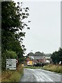
2
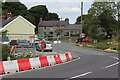
Roadworks on B4313 at Redstone Cross
New temporary course of Redstone Road, B4313, at its junction with the A40 Behind the cmaera there is a deep excavation, part of improvememts to the A40 and its junction with the B4313. Redstone Farm is in the background on the A40.
Image: © M J Roscoe
Taken: 1 Sep 2022
0.01 miles
3
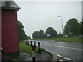
Staggered crossroads on the A40, Redstone Cross
Staggered crossroads on the A40 with the B4313 from Narberth to Maenclochog and Fishguard. The B4313 crosses the A40 trunk road at Redstone Cross, north of Narberth.
Image: © Martyn Harries
Taken: 24 Jul 2010
0.03 miles

5
Redstone Farm
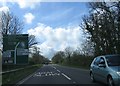
Approaching roadworks on the A40 near Narberth.
Image: © Alan Hughes
Taken: 5 Aug 2024
0.03 miles