IMAGES TAKEN NEAR TO
Llanddewi Velfrey, NARBERTH, SA67 7EH
Introduction
This page details the photographs taken nearby to SA67 7EH by members of the Geograph project.
The Geograph project started in 2005 with the aim of publishing, organising and preserving representative images for every square kilometre of Great Britain, Ireland and the Isle of Man.

There are currently over 7.5m images from over14,400 individuals and you can help contribute to the project by visiting https://www.geograph.org.uk
Image Map (Loading...)


Getting Data...Please wait
Leaflet Map data © OpenStreetMap
Images are licensed for reuse under creativecommons.org/licenses/by-sa/2.0
Notes
- Clicking on the map will re-center to the selected point.
- The higher the marker number, the further away the image location is from the centre of the postcode.
Image Listing (11 Images Found)
Images are licensed for reuse under creativecommons.org/licenses/by-sa/2.0
Image
Details
Distance
2
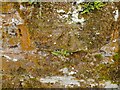
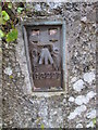
Ordnance Survey Cut Mark
This OS cut mark can be found on the wall of Pen Cwmmen Cottage. It marks a point 116.519m above mean sea level.
Image: © Adrian Dust
Taken: 13 Apr 2022
0.05 miles
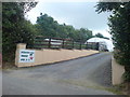
3
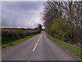
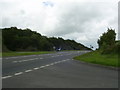
Old A40 near Llanddewi Velfrey
A view of a section of the former A40 between Llanddewi Velfrey and Whitland.
Image: © Martyn Harries
Taken: 6 May 2011
0.06 miles
4
Road embankment
A40 embankment near Llanddewi Velfrey.
Image: © Alan Hughes
Taken: 26 Nov 2019
0.08 miles
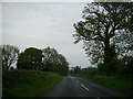
5
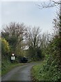
Old A40 road
Looking towards Llanddewi Velfrey on the old A40 road
Image: © chris whitehouse
Taken: 24 Apr 2012
0.11 miles
6
No way straight ahead
The bales of hay are stored on what was actually the original road. See also Image
Image: © Alan Hughes
Taken: 14 Nov 2021
0.13 miles
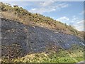
7
Interesting strata
Not natural strata but just various layers of road construction. Originally part of the A40, this bit of road surface has been left isolated following the construction of a re-aligned section of road.
Image: © Roger W Haworth
Taken: 4 Jun 2007
0.14 miles
8
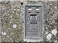
Ordnance Survey Flush Bracket G3227
This can be found on the wall of Gwyndy Farmhouse.
For more detail see : http://www.bench-marks.org.uk/bm15082
Image: © Peter Wood
Taken: 23 May 2013
0.19 miles
9
Ordnance Survey Flush Bracket (G3227)
This OS Flush Bracket can be found on Gwyndy Farmhouse. It marks a point 106.026m above mean sea level.
Image: © Adrian Dust
Taken: 6 Jul 2014
0.19 miles
10
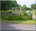
Road Junction near Llanddewi Velfrey
A view of the staggered junction with the A40 from the lane leading to Upper Fron and Waundwrgi.
Image: © Martyn Harries
Taken: 27 Aug 2011
0.19 miles