IMAGES TAKEN NEAR TO
Jesse Road, NARBERTH, SA67 7DP
Introduction
This page details the photographs taken nearby to Jesse Road, SA67 7DP by members of the Geograph project.
The Geograph project started in 2005 with the aim of publishing, organising and preserving representative images for every square kilometre of Great Britain, Ireland and the Isle of Man.

There are currently over 7.5m images from over14,400 individuals and you can help contribute to the project by visiting https://www.geograph.org.uk
Image Map
Images are licensed for reuse under creativecommons.org/licenses/by-sa/2.0
Notes
- Clicking on the map will re-center to the selected point.
- The higher the marker number, the further away the image location is from the centre of the postcode.
Image Listing (56 Images Found)
Images are licensed for reuse under creativecommons.org/licenses/by-sa/2.0
Image
Details
Distance
1
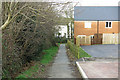
Path from Maesyrodyn to Jesse Road, Narberth
Image: © Dylan Moore
Taken: 23 Dec 2019
0.04 miles
3
Maesyrodyn, Narberth
There was never a kiln here: the name probably comes from Kilnpark (Parcyrodyn) half a kilometre to the east.
Image: © Dylan Moore
Taken: 23 Dec 2019
0.09 miles
4
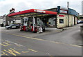
Eastgate Garage, Narberth
Murco filling station and Davies Narberth car sales, located alongside the A478 Jesse Road.
Image: © Jaggery
Taken: 31 Jul 2015
0.11 miles
5
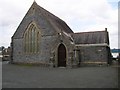
Former Wesleyan Church Narberth
Now a Masonic Lodge. Originally there was a small tower and spire.
Image: © Shaun Butler
Taken: 25 Sep 2008
0.11 miles
6
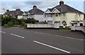
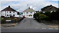
Station Road semis, Narberth
Semi-detached houses on the north side of the B4314 Station Road,
viewed from the corner of John Morgan Close. http://www.geograph.org.uk/photo/4594336
Image: © Jaggery
Taken: 31 Jul 2015
0.11 miles
7
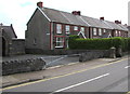
Wesley Villas, Narberth
Six semi-detached houses on the north side of Station Road.
The building on the left, http://www.geograph.org.uk/photo/4594955 now a Masonic Hall, was formerly a Wesleyan church or chapel.
Image: © Jaggery
Taken: 31 Jul 2015
0.11 miles
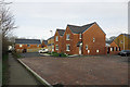
8
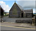
Masonic Hall, Narberth
Set back from Station Road near the corner of Jesse Road,
the Masonic Hall occupies a former Wesleyan church or chapel.
Image: © Jaggery
Taken: 31 Jul 2015
0.12 miles
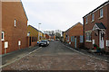
9
The Crescent, Narberth
Cul-de-sac viewed across Jesse Road.
Image: © Jaggery
Taken: 31 Jul 2015
0.12 miles
10
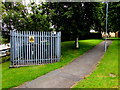
County School Narberth electricity substation
The Western Power Distribution substation is inside the grey metal fence above Station Road, alongside a path which formerly led to the County School, now the Old School Estate, occupied by several businesses.
The substation identifier is COUNTY SCHOOL NARBERTH S/S 601636.
Image: © Jaggery
Taken: 31 Jul 2015
0.13 miles