IMAGES TAKEN NEAR TO
Cwrt Llwynog, SWANSEA, SA6 6TW
Introduction
This page details the photographs taken nearby to Cwrt Llwynog, SA6 6TW by members of the Geograph project.
The Geograph project started in 2005 with the aim of publishing, organising and preserving representative images for every square kilometre of Great Britain, Ireland and the Isle of Man.

There are currently over 7.5m images from over14,400 individuals and you can help contribute to the project by visiting https://www.geograph.org.uk
Image Map
Images are licensed for reuse under creativecommons.org/licenses/by-sa/2.0
Notes
- Clicking on the map will re-center to the selected point.
- The higher the marker number, the further away the image location is from the centre of the postcode.
Image Listing (22 Images Found)
Images are licensed for reuse under creativecommons.org/licenses/by-sa/2.0
Image
Details
Distance
1
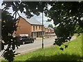
Housing at Heol Fran
Heol Fran, Cwmrhydyceirw.
Image: © Alan Hughes
Taken: 10 Jun 2019
0.05 miles
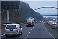
2
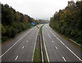
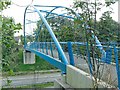
East along the M4 motorway, Morriston, Swansea
Viewed from this https://www.geograph.org.uk/photo/5943436 footbridge.
Image: © Jaggery
Taken: 16 Oct 2018
0.16 miles
4
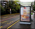
McDonald's advert on a Heol Maes Eglwys bus shelter, Morriston, Swansea
An advert for the cheesy bacon flat bread is on display on the Clear Channel advertising site on October 16th 2018.
Image: © Jaggery
Taken: 16 Oct 2018
0.19 miles
5
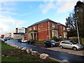
Plas Maesygwernen / Maesygwernen Hall
Adeiladwyd y plas presennol ar safle ffarm o'r un enw tua 1880 ar gyfer William Williams, diwydiannwr lleol ac aelod seneddol. Mae'r ty wedi hen gael ei amgylchynu gan Ysbyty Treforus a bu'r adeliad am flynyddau yn swyddfeydd yr ysbyty hwnnw. Yn anffodus mae dyfodol y plas dan fygythiad gan fod son mas bod yr awdurdodau am ei ddymchwel.
The present mansion house was built on the site of a farm of the same name circa 1880 for William Williams, a local industrialist and Liberal politician. The house has long been used as offices for Morriston Hospital. The future of the building is currently under threat as there is talk of it being demolished.
Image: © Alan Richards
Taken: 27 Feb 2017
0.19 miles
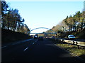
6
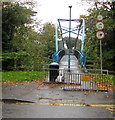
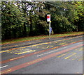
Prohibition signs at the northern end of an M4 motorway footbridge, Morriston, Swansea
Facing Heol Maes Eglwys on the approach to this https://www.geograph.org.uk/photo/5943436 footbridge,
signs show No Cycles, No Motor Vehicles, No Horses.
I wondered how a car could get past the two metal barriers and the lamppost...
Image: © Jaggery
Taken: 16 Oct 2018
0.19 miles
7
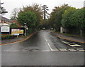
M is for Metro, Heol Maes Eglwys, Morriston, Swansea
The letter M on the bus stop sign indicates Metro. The stop is on Swansea Metro bus route 4 which extends from Singleton Hospital via Swansea city centre and Swansea railway station to Morriston Hospital (ahead).
Image: © Jaggery
Taken: 16 Oct 2018
0.20 miles
8
Clos George Morgan, Morriston, Swansea
From Heol Maes Eglwys, Clos George Morgan leads to the south side of Morriston Hospital.
A sign on the left shows speed limit 15mph.
Image: © Jaggery
Taken: 16 Oct 2018
0.20 miles