IMAGES TAKEN NEAR TO
Cwrt Hydd, SWANSEA, SA6 6TS
Introduction
This page details the photographs taken nearby to Cwrt Hydd, SA6 6TS by members of the Geograph project.
The Geograph project started in 2005 with the aim of publishing, organising and preserving representative images for every square kilometre of Great Britain, Ireland and the Isle of Man.

There are currently over 7.5m images from over14,400 individuals and you can help contribute to the project by visiting https://www.geograph.org.uk
Image Map
Images are licensed for reuse under creativecommons.org/licenses/by-sa/2.0
Notes
- Clicking on the map will re-center to the selected point.
- The higher the marker number, the further away the image location is from the centre of the postcode.
Image Listing (4 Images Found)
Images are licensed for reuse under creativecommons.org/licenses/by-sa/2.0
Image
Details
Distance
1
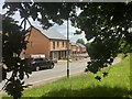
Housing at Heol Fran
Heol Fran, Cwmrhydyceirw.
Image: © Alan Hughes
Taken: 10 Jun 2019
0.15 miles
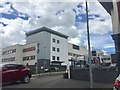
2
Ysbyty Treforys. Morriston Hospital.
Mae'r simdde amryliw ar y chwith yn un o nodweddion pensaerniol y fro.
The multi coloured chimney on the left is a prominent local landmark.
Image: © Gerallt Pennant
Taken: 16 Apr 2007
0.22 miles
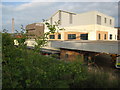
3
Morriston Hospital
Hospital buildings at Morriston Hospital.
Image: © Alan Hughes
Taken: 10 Jun 2019
0.24 miles
4
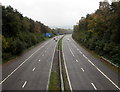
East along the M4 motorway, Morriston, Swansea
Viewed from this https://www.geograph.org.uk/photo/5943436 footbridge.
Image: © Jaggery
Taken: 16 Oct 2018
0.24 miles