IMAGES TAKEN NEAR TO
Andrew Crescent, SWANSEA, SA6 6RL
Introduction
This page details the photographs taken nearby to Andrew Crescent, SA6 6RL by members of the Geograph project.
The Geograph project started in 2005 with the aim of publishing, organising and preserving representative images for every square kilometre of Great Britain, Ireland and the Isle of Man.

There are currently over 7.5m images from over14,400 individuals and you can help contribute to the project by visiting https://www.geograph.org.uk
Image Map (Loading...)


Getting Data...Please wait
Leaflet Map data © OpenStreetMap
Images are licensed for reuse under creativecommons.org/licenses/by-sa/2.0
Notes
- Clicking on the map will re-center to the selected point.
- The higher the marker number, the further away the image location is from the centre of the postcode.
Image Listing (8 Images Found)
Images are licensed for reuse under creativecommons.org/licenses/by-sa/2.0
Image
Details
Distance
1
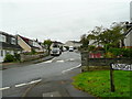
Christopher Road, Ynysforgan, Morriston
A suburb on the northern edge of the Swansea conurbation.
Image: © Jonathan Billinger
Taken: 15 Oct 2008
0.10 miles
2
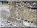
Ordnance Survey Cut Mark
This OS cut mark can be found on the wall of No469 Clydach Road. It marks a point 21.220m above mean sea level.
Image: © Adrian Dust
Taken: 17 May 2020
0.13 miles
3
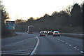
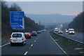
Swansea : M4 Motorway
The M4 Motorway heading westbound through the Swansea area.
Image: © Lewis Clarke
Taken: 10 Apr 2014
0.14 miles
6
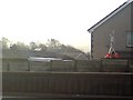
Pollution monitoring equipment on a house's garage
The curious looking device on a well weighed down tripod seen here on the roof of a house's garage is part of a network of pollution monitoring stations placed in various strategic locations around Swansea.
More information and recent data from this and other monitoring stations can be found at http://test.swansea.airqualitydata.com/cgi-bin/dustsites.cgi .
The picture was taken on the M4 motorway - a pileup just ahead had closed the road and was being cleared to the hard shoulder at the time the picture was taken.
Image: © Hywel Williams
Taken: 25 Feb 2008
0.17 miles
7
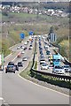
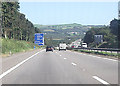
Swansea : M4 Motorway
The M4 Motorway heading eastbound through the Swansea area.
Image: © Lewis Clarke
Taken: 11 Apr 2014
0.22 miles
8
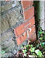
Ordnance Survey Cut Mark
This OS cut mark can be found on the parapet wall of the culvert east side of the road. It marks a point 17.864m above mean sea level.
Image: © Adrian Dust
Taken: 17 May 2020
0.25 miles