IMAGES TAKEN NEAR TO
Ynysforgan, SWANSEA, SA6 6QL
Introduction
This page details the photographs taken nearby to SA6 6QL by members of the Geograph project.
The Geograph project started in 2005 with the aim of publishing, organising and preserving representative images for every square kilometre of Great Britain, Ireland and the Isle of Man.

There are currently over 7.5m images from over14,400 individuals and you can help contribute to the project by visiting https://www.geograph.org.uk
Image Map
Images are licensed for reuse under creativecommons.org/licenses/by-sa/2.0
Notes
- Clicking on the map will re-center to the selected point.
- The higher the marker number, the further away the image location is from the centre of the postcode.
Image Listing (9 Images Found)
Images are licensed for reuse under creativecommons.org/licenses/by-sa/2.0
Image
Details
Distance
1
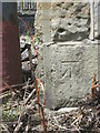
Ordnance Survey Cut Mark
This OS cut mark can be found on the south face buttress of the railway bridge. It marks a point 17.681m above mean sea level.
Image: © Adrian Dust
Taken: 3 Jun 2015
0.18 miles
2
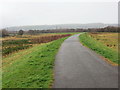
Llwybr Beicio / Cycle Path
Llwybr Beicio 43 yn mynd i gyfeiriad Pontardawe.
Cycle Path 43 heading in the direction of Pontardawe [trans. bridge over the Tawe River].
Image: © Alan Richards
Taken: 1 Mar 2017
0.19 miles
4
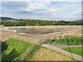
Lower Swansea Valley Flood Scheme Construction
The flood scheme map on site shows improvements to the river embankments from this point for nearly 2km downstream.
Here, the former Park & Ride gravel carpark is being turned into a "Community Recreation Area" at the same time as the existing embankment is being rebuilt further away from the river to create wetland habitat.
Image: © Nigel Davies
Taken: 29 Sep 2013
0.19 miles
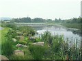
5
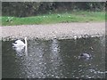
Swans on the river Tawe
Actual swans in Swansea !
There were about 3 white ones and one black one on this section of river. They didn't seem particularly frightened of the people from the caravan park on the west bank.
Image: © Nigel Davies
Taken: 14 Oct 2007
0.21 miles
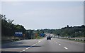
6
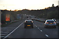
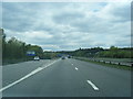
Swansea : M4 Motorway
The M4 Motorway heading westbound through the Swansea area.
Image: © Lewis Clarke
Taken: 10 Apr 2014
0.21 miles
7
Llwybr Beicio / Cycle Path
Llwybr Beicio 43 yn mynd i gyfeiriad Abertawe.
Cycle Path 43 heading in the direction of Swansea.
Image: © Alan Richards
Taken: 1 Mar 2017
0.23 miles
9
Small lake on the north edge of Llansamlet enterprise zone
This lake is sandwiched between a busy road and some levelled wasteland that is occasionally used as a park & ride for the Liberty Stadium (and an impromptu caravan park the rest of the time). Despite the litter and shopping trolleys, the ducklings and dragonflies are still surviving.
Image: © Nigel Davies
Taken: 22 Sep 2008
0.24 miles