IMAGES TAKEN NEAR TO
Cwrt Cilmeri, SWANSEA, SA6 6GJ
Introduction
This page details the photographs taken nearby to Cwrt Cilmeri, SA6 6GJ by members of the Geograph project.
The Geograph project started in 2005 with the aim of publishing, organising and preserving representative images for every square kilometre of Great Britain, Ireland and the Isle of Man.

There are currently over 7.5m images from over14,400 individuals and you can help contribute to the project by visiting https://www.geograph.org.uk
Image Map (Loading...)


Getting Data...Please wait
Leaflet Map data © OpenStreetMap
Images are licensed for reuse under creativecommons.org/licenses/by-sa/2.0
Notes
- Clicking on the map will re-center to the selected point.
- The higher the marker number, the further away the image location is from the centre of the postcode.
Image Listing (4 Images Found)
Images are licensed for reuse under creativecommons.org/licenses/by-sa/2.0
Image
Details
Distance
2
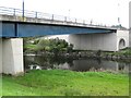
Bridge over Tawe river and paths
The river flows south into the Enterprise Zone and on to Swansea. This relatively new road bridge gives access to the north edge of the zone. A cycle path also runs near the river here
Image: © Nigel Davies
Taken: 22 Sep 2008
0.18 miles
3
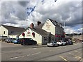
The Red Lion Inn
The Red Lion, Llansamlet.
Image: © Alan Hughes
Taken: 10 Aug 2018
0.18 miles
4
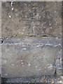
Ordnance Survey Cut Mark
This OS cut mark can be found on the wall of No197 Clydach Road. It marks a point 16.950m above mean sea level.
Image: © Adrian Dust
Taken: 3 Jun 2015
0.19 miles