IMAGES TAKEN NEAR TO
Mynachlogddu, CLYNDERWEN, SA66 7SE
Introduction
This page details the photographs taken nearby to SA66 7SE by members of the Geograph project.
The Geograph project started in 2005 with the aim of publishing, organising and preserving representative images for every square kilometre of Great Britain, Ireland and the Isle of Man.

There are currently over 7.5m images from over14,400 individuals and you can help contribute to the project by visiting https://www.geograph.org.uk
Image Map
Images are licensed for reuse under creativecommons.org/licenses/by-sa/2.0
Notes
- Clicking on the map will re-center to the selected point.
- The higher the marker number, the further away the image location is from the centre of the postcode.
Image Listing (22 Images Found)
Images are licensed for reuse under creativecommons.org/licenses/by-sa/2.0
Image
Details
Distance
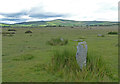
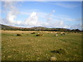
2
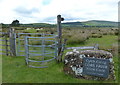
Bridleway and gate near the Gors Fawr Stone Circle
Image: © Mat Fascione
Taken: 5 Jun 2019
0.03 miles
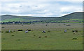
3
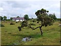
The view looking SSE from close to the Gors Fawr stone circle
Image: © pennyghael2
Taken: 11 Jul 2008
0.03 miles
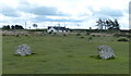
4
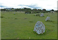
Gors Fawr Stone Circle
Gors Fawr is a stone circle 70 feet in diameter, composed of 16 low stones, 134 metres away are two outlying standing stones. It dates to circa 2300-1200 BC.
The circle is near the Preseli Mountains, where the "bluestones" of Stonehenge were quarried.
Image: © Mat Fascione
Taken: 5 Jun 2019
0.10 miles
5
Gors Fawr Stone Circle
Gors Fawr is a stone circle 70 feet in diameter, composed of 16 low stones, 134 metres away are two outlying standing stones. It dates to circa 2300-1200 BC.
The circle is near the Preseli Mountains, where the "bluestones" of Stonehenge were quarried.
Image: © Mat Fascione
Taken: 5 Jun 2019
0.10 miles
6
Gors Fawr Stone Circle
Gors Fawr is a stone circle 70 feet in diameter, composed of 16 low stones, 134 metres away are two outlying standing stones. It dates to circa 2300-1200 BC.
The circle is near the Preseli Mountains, where the "bluestones" of Stonehenge were quarried.
Image: © Mat Fascione
Taken: 5 Jun 2019
0.10 miles
7
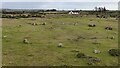
Gors Fawr Stone Circle
Nearly complete stone circle composed of relatively small stones (Scale 1m) https://coflein.gov.uk/en/site/300422/details/gors-fawr-stone-circle
Image: © Sandy Gerrard
Taken: 3 Feb 2016
0.10 miles
8
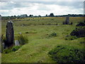
Standing stones and circle at Gors Fawr
The two outlying uprights stand a short distance NNE of the circle and there was once said to be an avenue leading between, suggesting they possessed a close relationship.
Image: © Bob Helms
Taken: 12 Jul 2009
0.11 miles
9
Looking NNE from Gors Fawr stone circle
View over the stone circle to the eastern end of the main Mynydd Preseli, with the rocky summit outcrops of Carn Menyn in the background.
Given that Carn Menyn is thought to be the source of the 'bluestone' dolerite stones at Stonehenge, it seems quite plausible that it's also the source of the rocks for many of the circles and other features in this area.
Image: © Richard Law
Taken: 27 Oct 2008
0.11 miles
10
Gors Fawr Stone Circle
Gors Fawr is a stone circle 70 feet in diameter, composed of 16 low stones, 134 metres away are two outlying standing stones. It dates to circa 2300-1200 BC.
The circle is near the Preseli Mountains, where the "bluestones" of Stonehenge were quarried.
Image: © Mat Fascione
Taken: 5 Jun 2019
0.11 miles