IMAGES TAKEN NEAR TO
Maenclochog, CLYNDERWEN, SA66 7RL
Introduction
This page details the photographs taken nearby to SA66 7RL by members of the Geograph project.
The Geograph project started in 2005 with the aim of publishing, organising and preserving representative images for every square kilometre of Great Britain, Ireland and the Isle of Man.

There are currently over 7.5m images from over14,400 individuals and you can help contribute to the project by visiting https://www.geograph.org.uk
Image Map
Images are licensed for reuse under creativecommons.org/licenses/by-sa/2.0
Notes
- Clicking on the map will re-center to the selected point.
- The higher the marker number, the further away the image location is from the centre of the postcode.
Image Listing (9 Images Found)
Images are licensed for reuse under creativecommons.org/licenses/by-sa/2.0
Image
Details
Distance
1
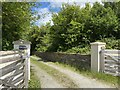
Honey Hook
Quaintly named farm near Maenclochog.
Image: © Alan Hughes
Taken: 12 May 2020
0.03 miles
2
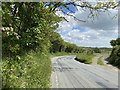
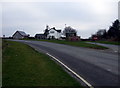
Road to Maenclochog
Sharp bend in the road to Maenclochog.
Image: © Alan Hughes
Taken: 12 May 2020
0.06 miles
3
Twmpath Guest House
Guest House near Maenclochog for sale.
Image: © Alan Hughes
Taken: 12 May 2020
0.06 miles
4
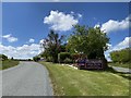
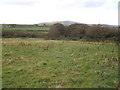
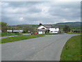
Country road in front of Twmpath
Country road in front of Twmpath near Maenclochog. The Preseli Hills can be seen in the background.
Image: © Philip Halling
Taken: 7 Apr 2013
0.08 miles
5
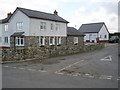
Twmpath
This guest house is the subject of the first Geograph Image The word twmpath, meaning a tump, mound or hummock, was applied to a place in a village where the community would gather to make music and make merry with singing and dancing, and the name is now applied to folk music sing-songs of that sort, the Welsh version of the ceilidh.
See http://www.omniglot.com/blog/2007/11/14/twmpath/
(On the earliest OS map of the area the name is Twmpath y cwn/dogs' mound.)
Image: © Natasha Ceridwen de Chroustchoff
Taken: 15 Feb 2008
0.09 miles
7
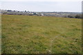
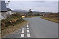
Farmland near Maenclochog
Farmland near Maenclochog which can be seen in the background.
Image: © Philip Halling
Taken: 7 Apr 2013
0.11 miles
9
House on an Island
This House just outside Maenclochog is surrounded by roads.
Image: © Jim Goldsmith
Taken: 6 May 2006
0.14 miles