IMAGES TAKEN NEAR TO
Golwg Yr Eglwys, CLYNDERWEN, SA66 7NS
Introduction
This page details the photographs taken nearby to Golwg Yr Eglwys, SA66 7NS by members of the Geograph project.
The Geograph project started in 2005 with the aim of publishing, organising and preserving representative images for every square kilometre of Great Britain, Ireland and the Isle of Man.

There are currently over 7.5m images from over14,400 individuals and you can help contribute to the project by visiting https://www.geograph.org.uk
Image Map (Loading...)


Getting Data...Please wait
Leaflet Map data © OpenStreetMap
Images are licensed for reuse under creativecommons.org/licenses/by-sa/2.0
Notes
- Clicking on the map will re-center to the selected point.
- The higher the marker number, the further away the image location is from the centre of the postcode.
Image Listing (77 Images Found)
Images are licensed for reuse under creativecommons.org/licenses/by-sa/2.0
Image
Details
Distance
1
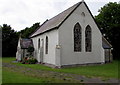
St David's church, Clunderwen
St David's church is part of the Church in Wales Diocese of St Davids. Set back 70 metres from
the west side of the A478, the main road through the village, the church is accessed via a path. http://www.geograph.org.uk/photo/4617606
Image: © Jaggery
Taken: 15 Aug 2015
0.02 miles
2
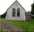
East side of St David's church, Clunderwen
Set back 70 metres from the west side of the A478, the main road through the village, the church is accessed
via a path. http://www.geograph.org.uk/photo/4617606 St David's church Clunderwen is part of the Church in Wales Diocese of St Davids.
Image: © Jaggery
Taken: 15 Aug 2015
0.02 miles
3
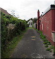
Path to St David's church, Clunderwen
Extending for 70 metres to the church http://www.geograph.org.uk/photo/4617601 from the west side of the A478.
Image: © Jaggery
Taken: 15 Aug 2015
0.02 miles
4
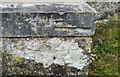
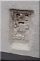
Ordnance Survey Cut Mark
This OS cut mark can be found on the SE angle of St David's Church. It marks a point 69.092m above mean sea level.
Image: © Adrian Dust
Taken: 15 Jan 2017
0.02 miles
5
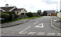
Golwg-yr-eglwys, Clunderwen
Cul-de-sac on the west side of the A478, the main road through the village.
Image: © Jaggery
Taken: 15 Aug 2015
0.02 miles
6
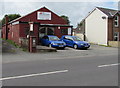
PW Motorsport in Clunderwen
VW and Audi specialists located in The Garage on the west side of the A478, the main road through the village.
Image: © Jaggery
Taken: 15 Aug 2015
0.04 miles
7
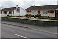
Stoneleigh B&B in Clunderwen
Bed-and-breakfast accommodation on the west side of the A478, the main road through the village.
Image: © Jaggery
Taken: 15 Aug 2015
0.05 miles
8
Ordnance Survey Flush Bracket (12019)
This OS Flush Bracket can be found on the west face of Ivy Cottage. It marks a point 68.912m above mean sea level.
Image: © Adrian Dust
Taken: 15 Jan 2017
0.05 miles
9
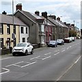
On-street parking in Clunderwen
Though this is the A478, the main road through Clunderwen, there are no yellow lines to prevent
on-street parking here. The local practice appears to be parking half on the road and half on the pavement.
Image: © Jaggery
Taken: 15 Aug 2015
0.06 miles
10
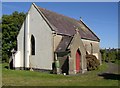
Clunderwen Church, Clynderwen
This little church is hard to find, being up a driveway with no sign. It was built c.1860 to serve the village that was developing alongside the Narberth road. The name of the village was taken from a farm, spelt like the modern community name, but was altered to have a 'u' instead of a 'y'.
Image: © Humphrey Bolton
Taken: 5 Oct 2007
0.06 miles