IMAGES TAKEN NEAR TO
Maenclochog, CLYNDERWEN, SA66 7LG
Introduction
This page details the photographs taken nearby to SA66 7LG by members of the Geograph project.
The Geograph project started in 2005 with the aim of publishing, organising and preserving representative images for every square kilometre of Great Britain, Ireland and the Isle of Man.

There are currently over 7.5m images from over14,400 individuals and you can help contribute to the project by visiting https://www.geograph.org.uk
Image Map (Loading...)


Getting Data...Please wait
Leaflet Map data © OpenStreetMap
Images are licensed for reuse under creativecommons.org/licenses/by-sa/2.0
Notes
- Clicking on the map will re-center to the selected point.
- The higher the marker number, the further away the image location is from the centre of the postcode.
Image Listing (5 Images Found)
Images are licensed for reuse under creativecommons.org/licenses/by-sa/2.0
Image
Details
Distance
1
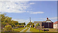
Site of former Maenclochog station, 1992
View northward towards Rosebush and Fishguard along the track-bed of the ex-GWR Clynderwen - Rosebush - Fishguard loop line. The station - actually behind the camera - and this part of the line (Clynderwen - Letterston) had been closed since 25/10/37 for passengers (16/5/49 for goods); passenger services Puncheston - Fishguard had ceased in 1922. However, goods continued Fishguard - Letterston until 1/3/65, also until 1995 by a another branch nearby to RNAD Trecwm and later until at least 2006. For a remarkable old poster, see Image
Image: © Ben Brooksbank
Taken: 24 Jun 2004
0.02 miles
2
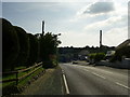
Country Road leaving Maenclochog
A view of a section of the country road heading for Gwastad and Llys-y-fran Reservoir Country Park from Maenclochog.
Image: © Martyn Harries
Taken: 9 Jun 2013
0.17 miles
3
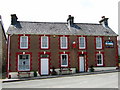
The Globe Inn
Maenclochog's only pub; in smart contrast to the shabby hulk of the former Castle Hotel that it faces.
Image: © Natasha Ceridwen de Chroustchoff
Taken: 10 Jun 2007
0.22 miles
4
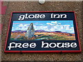
The Globe Inn sign
Showing a local scene: Waldo's stone and the Preseli mountain range.
Image: © Natasha Ceridwen de Chroustchoff
Taken: 10 Jun 2007
0.22 miles
5
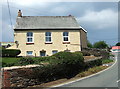
Old schoolroom/chapel
This building seems to have had 3 incarnations: first, between 1737 and 1777, as the venue for one of Mrs Bevan's circulating schools, an educational charity for poor children; it then became Tabernacle Chapel (dated 1901) for a breakaway congregation of the original village chapel; now it is a private house.
Image: © Natasha Ceridwen de Chroustchoff
Taken: 10 Jun 2007
0.23 miles