IMAGES TAKEN NEAR TO
Craig-Cefn-Parc, SWANSEA, SA6 5TP
Introduction
This page details the photographs taken nearby to SA6 5TP by members of the Geograph project.
The Geograph project started in 2005 with the aim of publishing, organising and preserving representative images for every square kilometre of Great Britain, Ireland and the Isle of Man.

There are currently over 7.5m images from over14,400 individuals and you can help contribute to the project by visiting https://www.geograph.org.uk
Image Map
Images are licensed for reuse under creativecommons.org/licenses/by-sa/2.0
Notes
- Clicking on the map will re-center to the selected point.
- The higher the marker number, the further away the image location is from the centre of the postcode.
Image Listing (6 Images Found)
Images are licensed for reuse under creativecommons.org/licenses/by-sa/2.0
Image
Details
Distance
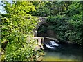
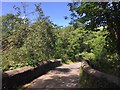
1
Pont Llechart
This is the view upstream from a public footpath beside the lower Clydach river. The bridge looks quite substantial from down here but actually only carries a narrow single track back road.
Image: © Nigel Davies
Taken: 10 Sep 2006
0.15 miles
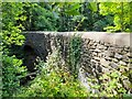
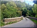
2
Pont Llechart
The bridge at Pont Llechart over the Lower Clydach River.
Image: © Alan Hughes
Taken: 1 Jul 2017
0.15 miles
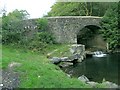
3
Pont Llechart
Bridge over the Clydach at Pont Llechart.
Image: © Alan Hughes
Taken: 7 Sep 2019
0.15 miles