IMAGES TAKEN NEAR TO
Rhyd Y Gwin, SWANSEA, SA6 5TF
Introduction
This page details the photographs taken nearby to Rhyd Y Gwin, SA6 5TF by members of the Geograph project.
The Geograph project started in 2005 with the aim of publishing, organising and preserving representative images for every square kilometre of Great Britain, Ireland and the Isle of Man.

There are currently over 7.5m images from over14,400 individuals and you can help contribute to the project by visiting https://www.geograph.org.uk
Image Map (Loading...)


Getting Data...Please wait
Leaflet Map data © OpenStreetMap
Images are licensed for reuse under creativecommons.org/licenses/by-sa/2.0
Notes
- Clicking on the map will re-center to the selected point.
- The higher the marker number, the further away the image location is from the centre of the postcode.
Image Listing (9 Images Found)
Images are licensed for reuse under creativecommons.org/licenses/by-sa/2.0
Image
Details
Distance
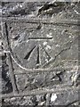
1
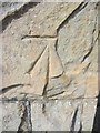
Ordnance Survey Cut Mark
This OS cut mark can be found on the east angle of the Congregational Chapel. It marks a point 145.877m above mean sea level.
Image: © Adrian Dust
Taken: 13 Mar 2014
0.08 miles
2
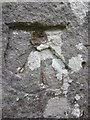
Ordnance Survey Cut Mark
This damaged OS cut mark can be found on the graveyard wall, NW face. It marks a point 162.288m above mean sea level.
Image: © Adrian Dust
Taken: 28 Aug 2013
0.10 miles
3
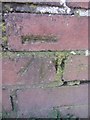
Ordnance Survey Cut Mark
This OS cut mark can be found on the gatepost of Maes Gwyn, Rhyd-y-gwin. It marks a point 168.832m above mean sea level.
Image: © Adrian Dust
Taken: 13 Mar 2014
0.13 miles
4
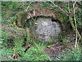
Sealed up mine in Cwm Clydach Nature Reserve
Right beside the maintained path up the east side of the river.
Image: © Nigel Davies
Taken: 22 Apr 2011
0.15 miles
5
Ordnance Survey Cut Mark
This OS cut mark can be found on the school wall. It marks a point 132.548m above mean sea level.
Image: © Adrian Dust
Taken: 13 Mar 2014
0.18 miles
6
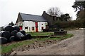
Ffarm Cathelyd Ganol Farm
Lleolir Ffarm Cathelyd Ganol uwchben Afon Clydach Isaf. Mae'r hen ffermdy bellach yn adfail.
Cathelyd Ganol Farm is located above the Lower Clydach River. The old farmhouse is now a ruin.
Image: © Alan Richards
Taken: 26 Jan 2014
0.18 miles
7
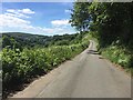
Cwm Clydach
View of road alongside Cwm Clydach.
Image: © Alan Hughes
Taken: 1 Jul 2017
0.18 miles
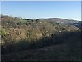
9
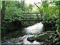
Footbridge over river Clydach
This footbridge is part of the trail system in the Cwm Clydach nature reserve.
Image: © Nigel Davies
Taken: 29 May 2006
0.21 miles