IMAGES TAKEN NEAR TO
Craig-Cefn-Parc, SWANSEA, SA6 5RW
Introduction
This page details the photographs taken nearby to SA6 5RW by members of the Geograph project.
The Geograph project started in 2005 with the aim of publishing, organising and preserving representative images for every square kilometre of Great Britain, Ireland and the Isle of Man.

There are currently over 7.5m images from over14,400 individuals and you can help contribute to the project by visiting https://www.geograph.org.uk
Image Map
Images are licensed for reuse under creativecommons.org/licenses/by-sa/2.0
Notes
- Clicking on the map will re-center to the selected point.
- The higher the marker number, the further away the image location is from the centre of the postcode.
Image Listing (5 Images Found)
Images are licensed for reuse under creativecommons.org/licenses/by-sa/2.0
Image
Details
Distance
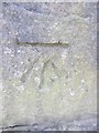
1
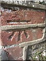
Ordnance Survey Cut Mark
This OS cut mark can be found on the wall of No6 Fagwr Road. It marks a point 128.117m above mean sea level.
Image: © Adrian Dust
Taken: 13 Mar 2014
0.17 miles
2
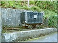
Commemorative mine dram in Craig Cefn Park
The battered old dram in a roadside alcove bears a plaque reading "In commemoration of all those villagers who worked in the local coal industry and built Craig Cefn Parc"
Image: © Nigel Davies
Taken: 23 May 2015
0.22 miles
3
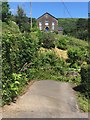
Elim Baptist Chapel
Elim Baptist Chapel built in 1891 for the community of Craig Cefn Parc.
Image: © Alan Hughes
Taken: 1 Jul 2017
0.22 miles
4
Miners Memorial
Memorial dedicated to miners from Craig Cefn Parc.
Image: © Alan Hughes
Taken: 1 Jul 2017
0.23 miles
5
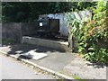
Ordnance Survey Cut Mark
This OS cut mark can be found on the wall next to the steps to the SW of the road. It marks a point 99.316m above mean sea level.
Image: © Adrian Dust
Taken: 13 Mar 2014
0.25 miles