IMAGES TAKEN NEAR TO
Wernfadog, Ynystawe, SWANSEA, SA6 5QY
Introduction
This page details the photographs taken nearby to SA6 5QY by members of the Geograph project.
The Geograph project started in 2005 with the aim of publishing, organising and preserving representative images for every square kilometre of Great Britain, Ireland and the Isle of Man.

There are currently over 7.5m images from over14,400 individuals and you can help contribute to the project by visiting https://www.geograph.org.uk
Image Map
Images are licensed for reuse under creativecommons.org/licenses/by-sa/2.0
Notes
- Clicking on the map will re-center to the selected point.
- The higher the marker number, the further away the image location is from the centre of the postcode.
Image Listing (6 Images Found)
Images are licensed for reuse under creativecommons.org/licenses/by-sa/2.0
Image
Details
Distance
1
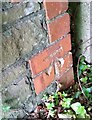
Ordnance Survey Cut Mark
This OS cut mark can be found on the parapet wall of the culvert east side of the road. It marks a point 17.864m above mean sea level.
Image: © Adrian Dust
Taken: 17 May 2020
0.11 miles
2
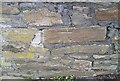
Ordnance Survey Cut Mark
This OS cut mark can be found on the wall SW side of Park Road. It marks a point 21.120m above mean sea level.
Image: © Adrian Dust
Taken: 17 Oct 2020
0.11 miles
3
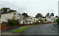
Bryntawe, Ynystawe
A very steep suburban road on the northern edge of the Swansea conurbation.
Image: © Jonathan Billinger
Taken: 15 Oct 2008
0.13 miles
4
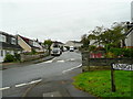
Christopher Road, Ynysforgan, Morriston
A suburb on the northern edge of the Swansea conurbation.
Image: © Jonathan Billinger
Taken: 15 Oct 2008
0.17 miles
5
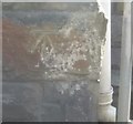
Ordnance Survey Cut Mark
This OS cut mark can be found on the school. It marks a point 22.9000m above mean sea level.
Image: © Adrian Dust
Taken: 29 Aug 2016
0.24 miles
6
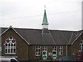
Ynystawe Primary School
The school spire was used by the Ordnance Survey as a 3rd Order Triangulation Point (Intersected Station SN80/INT009).
Image: © Adrian Dust
Taken: 31 Mar 2012
0.25 miles