IMAGES TAKEN NEAR TO
The Birches, SWANSEA, SA6 5NJ
Introduction
This page details the photographs taken nearby to The Birches, SA6 5NJ by members of the Geograph project.
The Geograph project started in 2005 with the aim of publishing, organising and preserving representative images for every square kilometre of Great Britain, Ireland and the Isle of Man.

There are currently over 7.5m images from over14,400 individuals and you can help contribute to the project by visiting https://www.geograph.org.uk
Image Map (Loading...)


Getting Data...Please wait
Leaflet Map data © OpenStreetMap
Images are licensed for reuse under creativecommons.org/licenses/by-sa/2.0
Notes
- Clicking on the map will re-center to the selected point.
- The higher the marker number, the further away the image location is from the centre of the postcode.
Image Listing (5 Images Found)
Images are licensed for reuse under creativecommons.org/licenses/by-sa/2.0
Image
Details
Distance
1
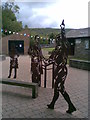
Swansea Canal Art Installation
Swansea Canal art installation at Clydach (Swansea Canal Walk).
Image: © Tawe Tours
Taken: Unknown
0.16 miles
2
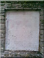
Swansea Canal Plaque
Swansea Canal plaque at Clydach (Swansea Canal Walk).
Image: © Tawe Tours
Taken: Unknown
0.17 miles
3
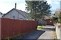
End view of drill halls in Capel Road/Enid Road
The smaller modern Cadet Force Drill Hall lies behind the Great War era Drill Hall.
Image: © John M
Taken: 4 Apr 2015
0.20 miles
4
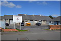
Workshops in Capel Road
Former Great War drill hall.
Image: © John M
Taken: 4 Apr 2015
0.20 miles
5
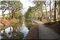
Camlas Abertawe / Swansea Canal
Adeiladwyd Camlas Abertawe rhwng 1794 a 1798 o Abercraf i Abertawe, pellter o 16 milltir a chludid glo, dur a haearn arni. Fe'i caewyd yn 1931. Yn 1981 sefydlwyd Cymdeithas Gamlas Abertawe er mwyn ei hadfer.
The Swansea Canal, built between 1794 and 1798 and sixteen miles in length, linked Abercraf with Swansea and transported mainly coal, steel and iron. The canal finally closed in 1931. In 1981 the Swansea Canal Society was formed and is committed in restoring the old waterway.
Image: © Alan Richards
Taken: 26 Jan 2014
0.21 miles