IMAGES TAKEN NEAR TO
High Street, SWANSEA, SA6 5LN
Introduction
This page details the photographs taken nearby to High Street, SA6 5LN by members of the Geograph project.
The Geograph project started in 2005 with the aim of publishing, organising and preserving representative images for every square kilometre of Great Britain, Ireland and the Isle of Man.

There are currently over 7.5m images from over14,400 individuals and you can help contribute to the project by visiting https://www.geograph.org.uk
Image Map
Images are licensed for reuse under creativecommons.org/licenses/by-sa/2.0
Notes
- Clicking on the map will re-center to the selected point.
- The higher the marker number, the further away the image location is from the centre of the postcode.
Image Listing (22 Images Found)
Images are licensed for reuse under creativecommons.org/licenses/by-sa/2.0
Image
Details
Distance
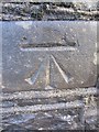
1
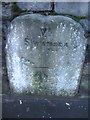
Mile Stone with OS Cut Mark
This Mile Stone, Swansea VI miles, has an Ordnance Survey cut mark which marks a point 26.661m above mean sea level. It can be found in the cemetery wall.
Image: © Adrian Dust
Taken: 28 Dec 2013
0.03 miles
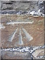
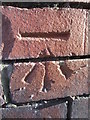
2
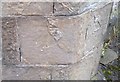
Ordnance Survey Cut Mark
This OS cut mark can be found on the north angle of St John's Church. It marks a point 87.5ft above mean sea level.
Image: © Adrian Dust
Taken: 3 Sep 2020
0.06 miles
3
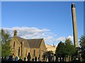
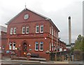
Church and Refinery at Clydach
The chimney stack of the nickel refinery dominates the town of Clydach near Swansea. Here it can be seen to the south of a church in the middle of town.
Image: © Nigel Davies
Taken: 29 May 2006
0.06 miles
4
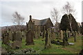
Church of St John the Baptist
Adeiladwyd yr eglwys yn 1847 gyda Theulu'r Miers o Blas Ynyspenllwch yn cwrdd a rhan fwyaf o'r gost. Yn anffodus mae'r addoldy bellach wedi bod ar gau ers sawl blwyddyn.
The church was built in 1847 with the Miers Family of Ynyspenllwch Mansion meeting most of the cost. Sadly, the place of worship has been closed now for several years.
Image: © Alan Richards
Taken: 26 Jan 2014
0.07 miles
5
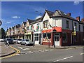
Mount Pleasant Shops
Row of shops at Mount Pleasant, Clydach.
Image: © Alan Hughes
Taken: 1 Jul 2017
0.08 miles
6
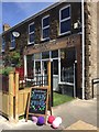
Coffee Shop
Cwtch Corner - a coffee shop in Clydach.
Image: © Alan Hughes
Taken: 1 Jul 2017
0.10 miles
7
Ordnance Survey Cut Mark
This OS cut mark can be found on No44 Lower Down Road. It marks a point 29.928m above mean sea level.
Image: © Adrian Dust
Taken: 28 Dec 2013
0.13 miles
8
Ordnance Survey Cut Mark
This OS cut mark can be found on the NE parapet of the canal bridge. It marks a point 23.896m above mean sea level.
Image: © Adrian Dust
Taken: 28 Dec 2013
0.13 miles
9
Ordnance Survey Cut Mark
This OS cut mark can be found on the Post Office, No43 High Street. It marks a point 27.938m above mean sea level.
Image: © Adrian Dust
Taken: 28 Dec 2013
0.13 miles
10
Mond Nickel Works, Clydach
The Mond Nickel Works adjoins the Swansea Canal at Clydach
Image: © Kevin Corcoran
Taken: 14 Oct 2014
0.14 miles