IMAGES TAKEN NEAR TO
Tyle-Teg, SWANSEA, SA6 5EA
Introduction
This page details the photographs taken nearby to Tyle-Teg, SA6 5EA by members of the Geograph project.
The Geograph project started in 2005 with the aim of publishing, organising and preserving representative images for every square kilometre of Great Britain, Ireland and the Isle of Man.

There are currently over 7.5m images from over14,400 individuals and you can help contribute to the project by visiting https://www.geograph.org.uk
Image Map (Loading...)


Getting Data...Please wait
Leaflet Map data © OpenStreetMap
Images are licensed for reuse under creativecommons.org/licenses/by-sa/2.0
Notes
- Clicking on the map will re-center to the selected point.
- The higher the marker number, the further away the image location is from the centre of the postcode.
Image Listing (10 Images Found)
Images are licensed for reuse under creativecommons.org/licenses/by-sa/2.0
Image
Details
Distance
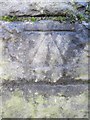
1
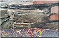
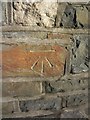
Ordnance Survey Cut Mark
This OS cut mark can be found on the wall of Brook Villa. It marked a point 38.95m above mean sea level.
Image: © Adrian Dust
Taken: 3 Sep 2020
0.11 miles
2
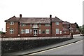
Clydach Hospital
Erected by the inhabitants of Clydach in 1924 in memory of those who fell in the first world war, this is also known as Clydach War Memorial Hospital.
See also Image
Image: © Nigel Davies
Taken: 6 May 2012
0.11 miles
3
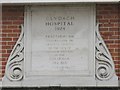
Dedication Plaque on Clydach Hospital
Detail of plaque from Image
Image: © Nigel Davies
Taken: 6 May 2012
0.11 miles
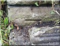
4
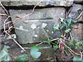
Ordnance Survey Cut Mark
This OS cut mark can be found on the wall to the north of Heol Dywyll. It marks a point 58.897m above mean sea level.
Image: © Adrian Dust
Taken: 28 Dec 2013
0.13 miles
5
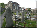
Bethania, Clydach
Mae'r garreg ar y wyneb yn dweud mai'r Parchedig Morgan Lewis adeiladodd y capel yn 1841 ac mai James Loid oedd y saer maen.
The stone between the upper windows commemorates the Rev. Morgan Lewis as the builder of the chapel and James Loid as the mason.
Image: © Gerallt Pennant
Taken: 16 Apr 2007
0.14 miles
6
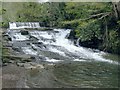
Weir and cascades on the Lower Clydach River at Forge Fach
This river has quite an industrial past with a tramway and many mines along its length. Barely anything remains now but there is a clogged leat and defunct sluices behind the pictured weir, plus the name of this area hints at an old forge.
Image: © Nigel Davies
Taken: 6 May 2012
0.18 miles
7
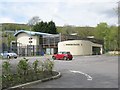
Forge Fach Community Resource Centre, Clydach
See http://www.forgefach.org.uk/ for details
Image: © Nigel Davies
Taken: 6 May 2012
0.21 miles
8
Ordnance Survey Cut Mark
This OS cut mark can be found at the junction of Quarr Drive & Hebron Road. It marks a point 26.128m above mean sea level.
Image: © Adrian Dust
Taken: 28 Dec 2013
0.22 miles
9
Ordnance Survey Cut Mark
This OS cut mark can be found on the SE face of Clydach Bridge. It marks a point 21.299m above mean sea level.
Image: © Adrian Dust
Taken: 28 Dec 2013
0.24 miles
10
Ordnance Survey Cut Mark
This OS cut mark can be found on the south angle of the Hebron Chapel. It marks a point 72.7ft above mean sea level.
Image: © Adrian Dust
Taken: 3 Sep 2020
0.24 miles