
IMAGES TAKEN NEAR TO
Players Industrial Estate, SWANSEA, SA6 5BB
Introduction
This page details the photographs taken nearby to Players Industrial Estate, SA6 5BB by members of the Geograph project.
The Geograph project started in 2005 with the aim of publishing, organising and preserving representative images for every square kilometre of Great Britain, Ireland and the Isle of Man.

There are currently over 7.5m images from over14,400 individuals and you can help contribute to the project by visiting https://www.geograph.org.uk
Image Map
Images are licensed for reuse under creativecommons.org/licenses/by-sa/2.0
Notes
- Clicking on the map will re-center to the selected point.
- The higher the marker number, the further away the image location is from the centre of the postcode.
Image Listing (17 Images Found)
Images are licensed for reuse under creativecommons.org/licenses/by-sa/2.0
Image
Details
Distance
1
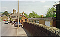
Clydach-on-Tawe: near South station
View NE, actually slightly NW of the station site. The ex-Midland Swansea Valley line at Clydach South station from Swansea St Thomas to Glais, Pontardawe/Brynamman - Ystalyfera - Colbren Junction and Brecon. The station was closed to passengers 25/9/50, but the line was closed from Colbren Junction in 9/32, so cutting off the Midland route via Brecon over the Neath & Brecon Railway. This left the traffic from Brynamman via Pontardawe, which lasted until 25/9/50 for passengers, 12/7/65 for goods. 'South' was added to the name only in 1/50, 'North' being on the goods-only branch of the GWR.
Image: © Ben Brooksbank
Taken: 20 May 1990
0.06 miles
2
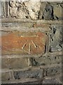
Ordnance Survey Cut Mark
This OS cut mark can be found at the junction of Quarr Drive & Hebron Road. It marks a point 26.128m above mean sea level.
Image: © Adrian Dust
Taken: 28 Dec 2013
0.10 miles
3
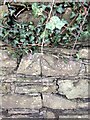
Cut mark on wall northside of Clydach Road
An ordnance survey cut mark can be found on the wall north side of Clydach Road, South facing.
Image: © John Jenkins
Taken: 25 Feb 2024
0.12 miles
4
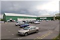
Clydach Market
Every Sunday for decades these sheds have housed travelling market stalls.
Edit:
In November 2012 it was announced that the market will close due to poor profits and the site will be sold for development: http://www.investegate.co.uk/Article.aspx?id=20121122155721P4842&tab=article
Image: © Nigel Davies
Taken: 6 May 2012
0.12 miles
5
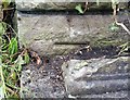
Ordnance Survey Cut Mark
This OS cut mark can be found on the south angle of the Hebron Chapel. It marks a point 72.7ft above mean sea level.
Image: © Adrian Dust
Taken: 3 Sep 2020
0.13 miles
6
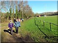
Cae rygbi y Faerdre / Vardre rugby field
Cerddwyr yn mynd heibio i gaeau rygbi y Faerdre.
Walkers passing Vardre RFC playing fields.
Image: © Alan Richards
Taken: 5 Apr 2015
0.14 miles
7
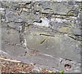
Ordnance Survey Cut Mark
This OS cut mark can be found on the wall NW side of Clydach Road. It marks a point 20.992m above mean sea level.
Image: © Adrian Dust
Taken: 17 May 2020
0.16 miles
8
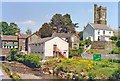
Clydach-on-Tawe, 1990
View NE on B4603 Hebron Road, by the river to St Mary's Church.
Image: © Ben Brooksbank
Taken: 20 May 1990
0.18 miles
9
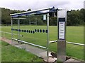
Viewing stand - or bus stop shelter?
From a distance, it seems that some new viewing shelters have been built on each side of the rugby pitch here.
Closer inspection indeed revealed that these stands *were* re-purposed bus stop shelters complete with their now non-functioning matrix display boards (inside) and a current timetable stating that the bus stop gave times from Swansea Railway Station.
One suspects that you'd be waiting a long time here if you wanted to catch the 17 the Gowerton or the 24 to Moriston Hospital...
Image: © Hywel Williams
Taken: 16 Aug 2009
0.18 miles
10
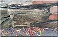
Ordnance Survey Cut Mark
This OS cut mark can be found on the wall of Brook Villa. It marked a point 38.95m above mean sea level.
Image: © Adrian Dust
Taken: 3 Sep 2020
0.20 miles