IMAGES TAKEN NEAR TO
Clydach Road, SWANSEA, SA6 5BA
Introduction
This page details the photographs taken nearby to Clydach Road, SA6 5BA by members of the Geograph project.
The Geograph project started in 2005 with the aim of publishing, organising and preserving representative images for every square kilometre of Great Britain, Ireland and the Isle of Man.

There are currently over 7.5m images from over14,400 individuals and you can help contribute to the project by visiting https://www.geograph.org.uk
Image Map
Images are licensed for reuse under creativecommons.org/licenses/by-sa/2.0
Notes
- Clicking on the map will re-center to the selected point.
- The higher the marker number, the further away the image location is from the centre of the postcode.
Image Listing (7 Images Found)
Images are licensed for reuse under creativecommons.org/licenses/by-sa/2.0
Image
Details
Distance
1
Swansea Canal (Ynystawe Works)
Ynystawe Patent Fuel Works (Swansea Canal Walk).
Image: © Tawe Tours
Taken: Unknown
0.08 miles
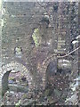
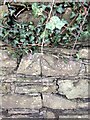
2
Ordnance Survey Cut Mark
This OS cut mark can be found on the wall NW side of Clydach Road. It marks a point 20.992m above mean sea level.
Image: © Adrian Dust
Taken: 17 May 2020
0.15 miles
3
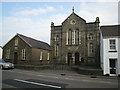
Moriah, Ynystawe.
Capel y Bedyddwyr, mae'r garreg uwchben y drysau yn cofnodi 1892 fel blwyddyn yr adeiladu. Helaethwyd yr adeilad yn 1928.
A Baptist chapel, the stone above the doors gives 1892 as the year of construction. The chapel was enlarged in 1928.
Image: © Gerallt Pennant
Taken: 16 Apr 2007
0.19 miles
4
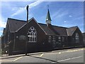
Ynystawe Primary School
Ynystawe Primary School, Clydach.
Image: © Alan Hughes
Taken: 1 Jul 2017
0.21 miles
5
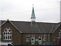
Ynystawe Primary School
The school spire was used by the Ordnance Survey as a 3rd Order Triangulation Point (Intersected Station SN80/INT009).
Image: © Adrian Dust
Taken: 31 Mar 2012
0.22 miles
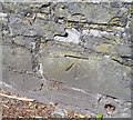
6
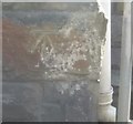
Ordnance Survey Cut Mark
This OS cut mark can be found on the school. It marks a point 22.9000m above mean sea level.
Image: © Adrian Dust
Taken: 29 Aug 2016
0.22 miles
7
Cut mark on wall northside of Clydach Road
An ordnance survey cut mark can be found on the wall north side of Clydach Road, South facing.
Image: © John Jenkins
Taken: 25 Feb 2024
0.23 miles