IMAGES TAKEN NEAR TO
Pontfaen, FISHGUARD, SA65 9TY
Introduction
This page details the photographs taken nearby to SA65 9TY by members of the Geograph project.
The Geograph project started in 2005 with the aim of publishing, organising and preserving representative images for every square kilometre of Great Britain, Ireland and the Isle of Man.

There are currently over 7.5m images from over14,400 individuals and you can help contribute to the project by visiting https://www.geograph.org.uk
Image Map
Images are licensed for reuse under creativecommons.org/licenses/by-sa/2.0
Notes
- Clicking on the map will re-center to the selected point.
- The higher the marker number, the further away the image location is from the centre of the postcode.
Image Listing (6 Images Found)
Images are licensed for reuse under creativecommons.org/licenses/by-sa/2.0
Image
Details
Distance
4
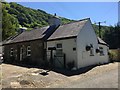
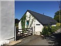
Entrance to Pwll-y-broga
Off the beaten track in the upper Gwaun valley.
Image: © Natasha Ceridwen de Chroustchoff
Taken: 5 Apr 2010
0.22 miles
5
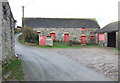
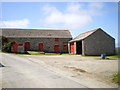
Trefach near Cilgwyn
It's not unusual to find a farm straddling the road in this hilly area of North Pembrokeshire, with the house on higher ground and the outbuildings below. The red doors are traditional.
Image: © Natasha Ceridwen de Chroustchoff
Taken: 17 Dec 2006
0.22 miles
6
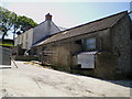
Penfeidr Cwm
Penfeidr Cwm, near Blaencwm, Cilgwyn.
Image: © Alan Hughes
Taken: 27 Jun 2018
0.23 miles