IMAGES TAKEN NEAR TO
Pontfaen, FISHGUARD, SA65 9TU
Introduction
This page details the photographs taken nearby to SA65 9TU by members of the Geograph project.
The Geograph project started in 2005 with the aim of publishing, organising and preserving representative images for every square kilometre of Great Britain, Ireland and the Isle of Man.

There are currently over 7.5m images from over14,400 individuals and you can help contribute to the project by visiting https://www.geograph.org.uk
Image Map
Images are licensed for reuse under creativecommons.org/licenses/by-sa/2.0
Notes
- Clicking on the map will re-center to the selected point.
- The higher the marker number, the further away the image location is from the centre of the postcode.
Image Listing (8 Images Found)
Images are licensed for reuse under creativecommons.org/licenses/by-sa/2.0
Image
Details
Distance
1
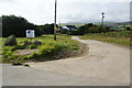
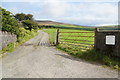
Farm access at Ty-gwyn
This road also gives access to Penralltddu and Tregynon.
Image: © Bill Boaden
Taken: 22 Aug 2011
0.06 miles
2
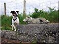
Two dogs
A stone sheepdog adorns the old churn stand below Ffynnondici: an appropriate symbol of the main farming activity in this hill countryside between the Preseli mountains and the Gwaun valley.
An alternative spelling of this farm's name is Ffynnon-y-ci/dog's well or spring, which may account for this canine adornment.
Image: © Natasha Ceridwen de Chroustchoff
Taken: 24 Jun 2007
0.09 miles
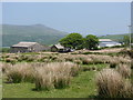
3
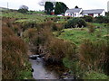
Berth Gwynne
Hillside smallholding beside mountain stream.
Image: © Natasha Ceridwen de Chroustchoff
Taken: 26 Dec 2007
0.20 miles
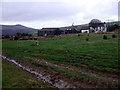
4
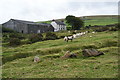
Sheep by Ffynnondici
This is on a long strip of access land between the farms.
Image: © Bill Boaden
Taken: 24 Aug 2011
0.20 miles
5
Entrance to Penlanwynt
A farm on the north western slopes of Foel Eryr.
Image: © Bill Boaden
Taken: 22 Aug 2011
0.24 miles
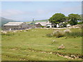
8
Ffynnondici and Carn Ingli
Hill farm below Cerrig Lladron; Carn Ingli silhouetted to the north.
Image: © Natasha Ceridwen de Chroustchoff
Taken: 26 Dec 2007
0.25 miles