IMAGES TAKEN NEAR TO
FISHGUARD, SA65 9QG
Introduction
This page details the photographs taken nearby to SA65 9QG by members of the Geograph project.
The Geograph project started in 2005 with the aim of publishing, organising and preserving representative images for every square kilometre of Great Britain, Ireland and the Isle of Man.

There are currently over 7.5m images from over14,400 individuals and you can help contribute to the project by visiting https://www.geograph.org.uk
Image Map (Loading...)


Getting Data...Please wait
Leaflet Map data © OpenStreetMap
Images are licensed for reuse under creativecommons.org/licenses/by-sa/2.0
Notes
- Clicking on the map will re-center to the selected point.
- The higher the marker number, the further away the image location is from the centre of the postcode.
Image Listing (4 Images Found)
Images are licensed for reuse under creativecommons.org/licenses/by-sa/2.0
Image
Details
Distance
1
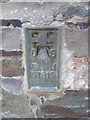
Ordnance Survey Flush Bracket (S7816)
This OS Flush Bracket can be found on a farm building, Rafael Farm. It marks a point 94.402m above mean sea level.
Image: © Adrian Dust
Taken: 5 Apr 2015
0.03 miles
2
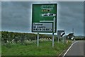
Junction On The A40
Going to St Davids from the A40
Image: © Deborah Tilley
Taken: 25 May 2015
0.13 miles
3
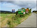
Approaching Fishguard on the A40
Motorists arriving in Fishguard are left in no doubt about the forthcoming local agricultural show.
Image: © Stephen McKay
Taken: 23 Jul 2006
0.16 miles
4
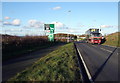
Fishguard bypass roundabout
The bypass around the western edge of the town leading to the ferry port at Goodwick was completed in the year 2000. Its main aim was to provide an access route to and from the port for large vehicles such as this one which previously caused problems passing through Fishguard and Goodwick.
Image: © Natasha Ceridwen de Chroustchoff
Taken: 6 Feb 2007
0.24 miles