IMAGES TAKEN NEAR TO
Manorowen, FISHGUARD, SA65 9QD
Introduction
This page details the photographs taken nearby to SA65 9QD by members of the Geograph project.
The Geograph project started in 2005 with the aim of publishing, organising and preserving representative images for every square kilometre of Great Britain, Ireland and the Isle of Man.

There are currently over 7.5m images from over14,400 individuals and you can help contribute to the project by visiting https://www.geograph.org.uk
Image Map
Images are licensed for reuse under creativecommons.org/licenses/by-sa/2.0
Notes
- Clicking on the map will re-center to the selected point.
- The higher the marker number, the further away the image location is from the centre of the postcode.
Image Listing (8 Images Found)
Images are licensed for reuse under creativecommons.org/licenses/by-sa/2.0
Image
Details
Distance
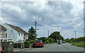
2
Roadside scene
On a rather drab Sunday morning.
Image: © Jeremy Bolwell
Taken: 3 Mar 2019
0.02 miles
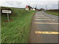
3
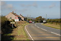
Panteg
The Village of Panteg, on the A487 St Davids to Fishguard Road
Image: © Jeremy Owen
Taken: 15 Sep 2006
0.02 miles
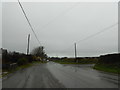
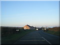
4
Panteg Near Goodwick
On the St Davids to Fishguard road
Image: © Deborah Tilley
Taken: 6 Sep 2015
0.03 miles
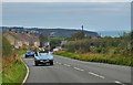
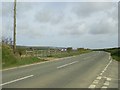
5
Panteg on the A487
Approach to the village of Panteg on the A487.
Image: © Alan Hughes
Taken: 7 Nov 2017
0.06 miles
7
Field by the A487, Panteg
Fishguard hosted the 1986 National Eisteddfod of Wales in the field opposite this road junction, about three miles away in Panteg. After the heavy rain on the first day of the Eisteddfod and the wet weather experienced during the week, this field became wet and very muddy.
Image: © Martyn Harries
Taken: 24 Mar 2009
0.17 miles
8
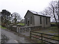
Old chapel in Panteg, Pembrokeshire
A venerable old chapel. This heritage is being lost. Shame.
Image: © Jeremy Bolwell
Taken: 3 Mar 2019
0.24 miles